Old Maps of Concord, California for Genealogy
Trace your family roots with 72 historic maps of Concord. These high-res maps reveal old neighborhoods, homesites, landmarks, and streets — helping you uncover where your ancestors lived and how the area evolved over time.
- Explore historic neighborhoods: Identify where your relatives may have lived in the 1800s or 1900s.
- Compare maps over time: Trace the changes in streets, buildings, and landmarks for multi-generational research.
- Perfect for genealogy & ancestry research: Used by family historians and researchers to map out lineage and migration.
These maps are an incredible resource for exploring your personal connection to Concord's past.
Concord, CA maps
(72)- 1896 Map of Carquinez Strait, 1954 Print
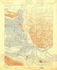
 1896 Carquinez Strait1954 Print · USGSThe industrial waterfront of the Carquinez Strait comes alive in the 1890s, where shipping channels meet the rails. Genealogists and historians can trace early bay settlements from the U.S. Arsenal at Benicia to the rail hubs of Vallejo and Martinez.
 - 1896 Map of Mt. Diablo, 1964 Print
 1896 Mt. Diablo1964 Print · USGSThe northern slopes of the Diablo Range come alive in the 1890s, where mining settlements like Nortonville and Somersville thrived alongside the Empire R. R. and Star Mine. Trace early rail lines, family landmarks, and the rural roots of Danville and San Ramon.
 - 1897 Map of Concord
 1897 Concord1897 Print · USGSThe East Bay hills and valleys appear here in the late nineteenth century, just as railroads began to reshape the old rancho lands. Researchers can trace the original tracks of the California and Nevada R. R. and early settlements like Pacheco and Lafayette.6 unique versions available
 - 1898 Map of Karquines
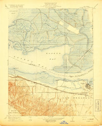
 1898 Karquines1898 Print · USGSThe Karquines Strait and Suisun Bay served as a bustling maritime and rail crossroads in the late nineteenth century. Researchers can trace the early layouts of Benicia, Vallejo, and Martinez, or locate vanished landmarks like Seal Bluff Landing and the U.S. Arsenal.
 - 1898 Map of Mt. Diablo
 1898 Mt. Diablo1898 Print · USGSContra Costa County at the end of the nineteenth century was a rugged landscape of coal mining camps and cattle valleys. Genealogists and local historians can trace the early footprints of Nortonville, Stewartville, and the remote Star Mine nestled among the peaks of Monte del Diablo.7 unique versions available
 - 1901 Map of Karquines
 1901 Karquines1901 Print · USGSNorthern California at the dawn of the twentieth century shows a landscape defined by the deep-water Karquines Strait and industrial rail hubs. Researchers can trace the waterfront activity of Benicia, Vallejo, and Martinez or the tidal marsh outposts at Drawbridge and Rush Landing.6 unique versions available
 - 1902 Map of Napa
 1902 Napa1902 Print · USGSThe Napa Valley and Carquinez Strait are captured at the turn of the century, showing a landscape defined by maritime military posts and early vineyards. Genealogists and historians can trace the Mare Island Navy Yard, the Insane Asylum, and rail stops at Zinfandel and Rutherford.6 unique versions available
 - 1907 Map of Antioch, 1955 Print
 1907 Antioch1955 Print · USGSThe Suisun Bay and Sacramento Delta regions are captured here in the early twentieth century during a period of agricultural and industrial expansion. Local historians can trace family-named river ports like Lingos Landing and rural landmarks such as Scandia School or the settlement of Birds Landing.
 - 1908 Map of Antioch
 1908 Antioch1908 Print · USGSThe convergence of the great California rivers in the early twentieth century shows a landscape of busy water landings and growing rail towns. Trace the industrial roots of Antioch or locate vanished landings like Palmetto Landing and Duttons Landing along the sloughs.5 unique versions available
 - 1915 Map of Concord
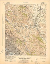
 1915 Concord1915 Print · USGSContra Costa and Alameda counties are shown here just before the mid-century population boom, when the East Bay was a landscape of ranchos and rail stops. Genealogists can trace family footprints in small 1910s settlements like Moraga, Pacheco, and Lafayette.5 unique versions available
 - 1918 Map of Honker Bay
 1918 Honker Bay1918 Print · USGSThe industrial waterfront of Contra Costa and Solano counties comes alive in this survey of the Sacramento River delta. Trace the rail networks at Pittsburg and find historic riverfront stops like Birds Landing and Yolo Landing.2 unique versions available
 - 1940 Map of Carquinez Strait, 1963 Print
 1940 Carquinez Strait1963 Print · USGSThe industrial waterfronts of Solano and Contra Costa counties are captured here just before the mid-century boom. Genealogists and historians can trace the rail-and-water networks of Port Costa, Benicia, and Vallejo, or locate landmarks like the Carquinez Cem and the Benicia Auto Ferry.2 unique versions available
 - 1942 Map of Concord
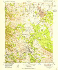
 1942 Concord1942 Print · USGSThe East Bay interior was a landscape of expanding valley towns and deep-rooted ranching tracts in the early 1940s. Genealogists and historians can trace rail-era settlements like Concord, Lafayette, and Walnut Creek alongside local landmarks like St Marys College and Sherman Field.
 - 1942 Map of Carquinez
 1942 Carquinez1942 Print · USGSThe industrial waterfront of the Carquinez Strait is captured here during the early years of the war. Researchers can trace the complex rail networks of the Southern Pacific and locate established neighborhoods in Vallejo, Benicia, and Crockett.
 - 1943 Map of Concord
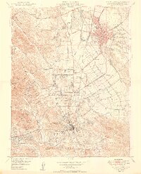
 1943 Concord1943 Print · USGSThe East Bay and Contra Costa interior appear here during the wartime era, showing the transition from urban waterfronts to rural valley communities. Researchers can trace early rail lines like the Sacramento Northern RR and locate local landmarks such as St Marys College and Acalanes Sch.
 - 1943 Map of Mt. Diablo
 1943 Mt. Diablo1943 Print · USGSThe Mt. Diablo foothills and San Ramon Valley are captured here during the early 1940s, showcasing a landscape of cattle ranches and remote schoolhouses. Genealogists and local historians can locate early landmarks like Blackhawk Ranch, Cowell, and the Morgan Territory Sch.
 - 1947 Map of Santa Rosa
 1947 Santa Rosa1947 Print · USGSNorthern California in the late 1940s was a landscape of agricultural valleys and vital rail hubs. Trace the historic routes of the Northwestern Pacific through Healdsburg or explore the mid-century waterfronts of Vallejo and Benicia near Mare Island.
 - 1947 Map of San Francisco, 1948 Print
 1947 San Francisco1948 Print · USGSThe Bay Area in the late 1940s reveals a region transitioning from wartime intensity to post-war suburban growth. Trace the historic rail lines of the Southern Pacific RR or locate early military footprints at Fort Funston and Moffett Field.
 - 1947 Map of Sacramento, 1948 Print
 1947 Sacramento1948 Print · USGSThe Sacramento Valley meets the high Sierra during a period of post-war expansion. Trace the historic river delta islands like Grand Island or locate early airfield footprints at McClellan Air Force Base and Mather Air Force Base.2 unique versions available
 - 1947 Map of San Jose, 1948 Print
 1947 San Jose1948 Print · USGSNorthern California's heartland is captured here just after the war, showing the rapid growth of the Santa Clara and Central Valleys. Researchers can trace the legacy of rail and water at Castle Air Force Base, Stockton, and the Hetch Hetchy Aqueduct.
 - 1947 Map of Walnut Creek, 1954 Print
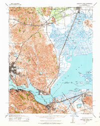
 1947 Walnut Creek1954 Print · USGSCentral Contra Costa County is shown here in the late 1940s, transitioning from a landscape of quiet valleys and orchards to a growing suburban network. Researchers can trace the heritage of Walnut Creek and Concord through landmarks like the Fernando Adobe and the Sacramento Northern rail lines.
 - 1948 Map of Sacramento, 1951 Print
 1948 Sacramento1951 Print · USGSPost-war Northern California comes alive in this regional survey, capturing the era of expansion between the Central Valley and the High Sierra. Researchers can trace the rail networks of the Central California Traction and Sacramento Northern RR or locate landmarks like the State Capitol and University of California Davis.
 - 1948 Map of San Francisco, 1951 Print
 1948 San Francisco1951 Print · USGSThe Bay Area in the late 1940s reveals a landscape defined by rapid post-war growth and a heavy military presence at the Golden Gate. Trace the development of early trans-bay infrastructure like the Oakland-Bay Bridge and historic coastal defense sites such as Fort Funston and Alcatraz Island.
 - 1949 Map of Walnut Creek
 1949 Walnut Creek1949 Print · USGSPost-war Contra Costa County is shown here as suburban growth begins to reach into the valley's traditional orchards and rail corridors. Trace the development of Concord and Walnut Creek through landmarks like Buchanan Field, St Stephens Cem, and the Sacramento Northern line.2 unique versions available
 - 1949 Map of Santa Rosa
 1949 Santa Rosa1949 Print · USGSThe North Bay and Wine Country appear here in the late 1940s, when the Northwestern Pacific RR still dominated regional transit. Genealogists and historians can trace old coastal outposts like Anchor Bay Settlement and the early layout of Santa Rosa.2 unique versions available
Showing maps 1-25 of 72
Top cities near Concord
- Oakland historical maps
- Vallejo historical maps
- Fairfield historical maps
- Antioch historical maps
- San Ramon historical maps
- Piedmont historical maps
See more
Top neighborhoods of Concord
- Meinert historical maps
- Cowell historical maps
- Sun Terrace historical maps
- Brookview Park historical maps
- Ygnacio Wood historical maps
- Rose Glen historical maps
See more
Frequently asked questions
- What are the different types of historical maps available for Concord?
- What is the oldest map of Concord?
- Where can I purchase historical maps of Concord for my home or office?
- Where can I download high-res historical maps of Concord?
- Are there historical topographic maps available for Concord?
- Is there historical aerial imagery available for Concord?
- Where are historical maps of Concord sourced from?