1960s Maps of Crescent City, California
Explore 3 historic maps of Crescent City from the 1960s. These maps offer a rare glimpse into what life looked like during the 1960s — showing old roads, neighborhoods, homes, and landmarks that have changed or disappeared over time.
Whether you're researching your family's past, planning a metal detecting trip, or studying how Crescent City's landscape evolved across the 1960s, these high-resolution maps are a powerful tool for exploring the history of this region.
- Focus on a specific era: All maps on this page are from the 1960s, giving you a focused view of this time period.
- See what’s changed: Compare century-old streets, trails, and buildings to today's modern landscape using overlays and satellite layers.
- Research with precision: Use these maps for genealogy, historical research, land use analysis, or educational projects.
- View, download, or print: Maps are fully viewable online in high resolution, and can be downloaded or printed for your own records.
Start exploring Crescent City's history through authentic maps from the 1960s. This is your window into the past.
Crescent City, CA maps
(3)- 1961 Map of Eureka
 1961 Eureka1961 Print · USGSThe Northern California coast and its deep redwood forests are mapped here at a time when the timber and rail industries defined the region. Researchers can trace historic family ranches and remote sites like Fort Dick, Table Bluff Lighthouse, and the Copper Creek Mine.2 unique versions available
 - 1966 Map of Sister Rocks, 1968 Print
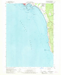 1966 Sister Rocks1968 Print · USGSCoastal Del Norte County in the mid-1960s shows the working harbor of Crescent City alongside the emerging conservation of the redwoods. Researchers can trace the maritime footprint of Citizens Dock, the Battery Point Lighthouse, and coastal landmarks like Sister Rocks.3 unique versions available
 - 1966 Map of Crescent City, 1968 Print
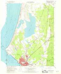 1966 Crescent City1968 Print · USGSCrescent City and the Del Norte coastline are captured here in the mid-1960s, showing the town's expansion alongside the massive coastal lagoons. Genealogists and researchers can trace local landmarks like Fort Dick, Elk Valley Sch, and the unique SS Emidio Memorial on the Pacific shore.6 unique versions available
End of results
Showing maps 1-3 of 3
Top cities near Crescent City
Frequently asked questions
- What are the different types of historical maps available for Crescent City?
- What is the oldest map of Crescent City?
- Where can I purchase historical maps of Crescent City for my home or office?
- Where can I download high-res historical maps of Crescent City?
- Are there historical topographic maps available for Crescent City?
- Is there historical aerial imagery available for Crescent City?
- Where are historical maps of Crescent City sourced from?