Old Maps of Del Norte County, California
Explore 200 old maps of Del Norte County, spanning from 1917 to today. These high-resolution historic maps reveal how streets, neighborhoods, landmarks, and natural features evolved over time — perfect for genealogy, metal detecting, research, and local history exploration.
What you can do with these maps:
- See how Del Norte County changed over time: Compare historical maps to modern-day views to trace roads, homesites, rail lines & more.
- View detailed metadata: Each map includes creators, publishers, year, scale, and archive source.
- Overlay maps with satellite & LiDAR: Visualize the past alongside modern tools to explore terrain & human change.
- Trusted historical sources: Maps sourced from the USGS, Library of Congress, and other archives.
- Access maps your way: View online, download high-res files, or order prints for personal or research use.
Start exploring old maps of Del Norte County to uncover forgotten places, hidden landmarks, and the deep history beneath your feet.
Del Norte County, CA maps
(200)- 1917 Map of Kerby, 1927 Print
 1917 Kerby1927 Print · USGSSouthern Oregon's mining and timber country is documented here during the early twentieth century, showing the Illinois River basin at its industrial peak. Genealogists can trace family homesteads and local institutions through Kerby, Selma, and rural schools like Spence School.3 unique versions available
 - 1918 Map of Kerby
 1918 Kerby1918 Print · USGSJosephine County in the years before the Great War was a center of mountain mining and early forestry. Genealogists and historians can trace the pioneer footprints of Waldo, Kerby, and Takilma, alongside remote operations like the Queen of Bronze Mine and Eureka Mine.2 unique versions available
 - 1922 Map of Preston Peak
 1922 Preston Peak1922 Print · USGSThe California-Oregon borderlands are mapped here just before the era of modern highway expansion, showing a network of remote river bars and mountain ranches. Trace the locations of early outposts like Gasquet Adams Sta, the Cleopatra Mine, and Terwer School.5 unique versions available
 - 1925 Map of Hoopa
 1925 Hoopa1925 Print · USGSNorthwestern California in the mid-twenties centers on the vital corridors of the Klamath River and the Hoopa Valley Indian Reservation. Genealogists and historians can trace riverside settlements and landmarks like Martins Ferry, Weitchpec, and Orleans.
 - 1929 Map of Crescent City
 1929 Crescent City1929 Print · USGSCoastal Del Norte County appears here during the late 1920s, showing the early infrastructure of the redwood coast. Genealogists and researchers can trace family-named sites like Bald Hill Ranch, the Tyson Chrome Mines, and the waterfront of Crescent City.
 - 1945 Map of Ship Mountain
 1945 Ship Mountain1945 Print · USGSIn the mid-1940s, the remote ridges of Del Norte County were defined by a series of high-altitude lookouts and family ranches. Researchers can trace historic river access and mountain life through features like the Chrome Mine, Turwar School, and the Knapp Estate.
 - 1945 Map of Orick
 1945 Orick1945 Print · USGSCoastal Humboldt County was a landscape of dense redwood forests and isolated ranching outposts just after the war. Researchers can trace early family sites like Hufford Ranch, find the State Fish Hatchery, and locate the offshore Redding Rock Lighthouse.
 - 1945 Map of Kerby
 1945 Kerby1945 Print · USGSJosephine County at the close of the war shows a landscape of deep-woods mining and early forest management. Genealogists and historians can trace family roots through labels for Dryden Sch, the Hancock Ranch, and the early community at Takilma.
 - 1945 Map of Gasquet
 1945 Gasquet1945 Print · USGSThe northern California mountains near the Oregon border are shown here during the mid-1940s, a period defined by remote mining and forest service outposts. Genealogists and historians can trace family locations and old worksites like Adams Station, the Tyson Chrome Co Mine, and the Lee Brown Ranch.
 - 1945 Map of Point St. George
 1945 Point St. George1945 Print · USGSCrescent City and the Del Norte coast are captured here mid-century, showing a landscape of timber, mines, and military outposts. Researchers can trace the Tyson Chrome Mine, find the Indian Cemetery, or locate the wartime Naval Airport.
 - 1945 Map of Requa
 1945 Requa1945 Print · USGSThe Del Norte coast at the end of World War II shows a landscape defined by the redwood timber trade and the mouth of the Klamath River. Researchers can locate the Klamath Cedar Co Sawmill, the Requa School, and the settlement at Waukell Flat.
 - 1945 Map of Tectah Creek
 1945 Tectah Creek1945 Print · USGSThe Klamath River corridor comes to life in the mid-1940s, showing a network of remote riverside settlements and upland prairies. Genealogists and researchers can locate family-named sites like McCOVEY RANCH and historic community hubs like Pecwan-Union School.
 - 1948 Map of Weed, 1950 Print
 1948 Weed1950 Print · USGSNorthern California and Southern Oregon are captured here during the post-war era, documenting the mountain-and-valley economies of the Klamath and Cascade ranges. Trace the legacy of local mining and timber at the King Solomon Mine, find old schools like Siskiyou County School, and follow the historic Southern Pacific RR route.2 unique versions available
 - 1949 Map of Eureka
 1949 Eureka1949 Print · USGSCoastal Northern California in the late 1940s shows a landscape of timber towns and maritime outposts. You can trace the Northwestern Pacific rail line through Eureka or locate family landmarks like the Tyson Chrome Mine and Crescent City Lighthouse.2 unique versions available
 - 1950 Map of Weed
 1950 Weed1950 Print · USGSSiskiyou County and the surrounding Klamath mountains appear in the mid-century before extensive modern development. Genealogists and local historians can locate remote outposts like the Lee Brown Ranch and the specialized settlement of Darlingtonia.
 - 1951 Map of Gasquet, 1953 Print
 1951 Gasquet1953 Print · USGSDel Norte County's rugged mining and timber country is captured here during the early fifties, centering on the Smith River corridor. Genealogists and researchers can trace local operations like the Morrell Placer Mine, locate remote outposts like Elk Camp, and find early settlements at Gasquet and Darlingtonia.5 unique versions available
 - 1952 Map of Orick, 1954 Print
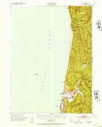 1952 Orick1954 Print · USGSThe northern California coast and its redwood forests appear here in the early fifties, centering on the valley of Redwood Creek. Local historians can trace the foundations of the park system and early settlements like Orick, Hufford Ranch, and the State Fish Hatchery.2 unique versions available
 - 1952 Map of Ship Mountain, 1954 Print
 1952 Ship Mountain1954 Print · USGSThe Del Norte backcountry in the early fifties shows a remote landscape of forest lookouts and riverside ranching. Genealogists and historians can trace isolated family outposts like Wilson Ranch and Alma Ranch or locate early forest camps such as Marlow Camp.3 unique versions available
 - 1952 Map of Klamath, 1954 Print
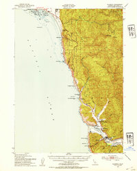 1952 Klamath1954 Print · USGSThe Del Norte coast comes alive in the early fifties, showing the rugged interface between the redwoods and the Pacific. Trace the river economy near the Klamath River through landmarks like the Veneer Mill, Requa Sch, and the Douglas Mem Bridge.3 unique versions available
 - 1952 Map of Orleans, 1954 Print
 1952 Orleans1954 Print · USGSThe Klamath River corridor near the tri-county border appears here in the early fifties, showing a landscape of forest service outposts and family ranching. Researchers can locate the Reece Homestead, the Hunter Little Ranch, and historical mining sites like the Owl Mine.3 unique versions available
 - 1952 Map of Tectah Creek, 1954 Print
 1952 Tectah Creek1954 Print · USGSThe Klamath River corridor in the early fifties shows a landscape of river-dependent settlements and isolated mountain ranches. Genealogists and researchers can locate Mc Covey Ranch, the Pecwan Union School, and riverside points like Johnsons.3 unique versions available
 - 1952 Map of Crescent City, 1954 Print
 1952 Crescent City1954 Print · USGSCoastal Del Norte County appears here in the early fifties, from the Oregon border down to the streets of Crescent City. Genealogists and historians can trace indigenous sites like Yontocket and the Indian Cemetery or locate old operations like the Lind Mine.4 unique versions available
 - 1954 Map of Cave Junction, 1956 Print
 1954 Cave Junction1956 Print · USGSThe Illinois River valley in Southern Oregon comes alive in the mid-fifties, showing a landscape of mining camps and timber towns before modern development. Researchers can trace family sites at Takilma, locate the old Waldo townsite, or find historic workings like the Esterly Mine.3 unique versions available
 - 1955 Map of Dillon Mtn, 1957 Print
 1955 Dillon Mtn1957 Print · USGSNorthern California’s high country near the Klamath River is captured here in the mid-fifties. Genealogists and local historians can locate remote landmarks like the Kennedy Homestead, Cottage Grove, and the old Ti Bar School.3 unique versions available
 - 1955 Map of Medford, 1964 Print
 1955 Medford1964 Print · USGSSouthern Oregon's valley towns and high peaks are captured here in the mid-1950s, showing the region before the completion of the modern interstate system. Genealogists and historians can trace the development of timber and mining outposts from Wolf Creek to Butte Falls and the early roads to Crater Lake.3 unique versions available
Showing maps 1-25 of 200
Top cities of Del Norte County
Frequently asked questions
- What are the different types of historical maps available for Del Norte County?
- What is the oldest map of Del Norte County?
- Where can I purchase historical maps of Del Norte County for my home or office?
- Where can I download high-res historical maps of Del Norte County?
- Are there historical topographic maps available for Del Norte County?
- Is there historical aerial imagery available for Del Norte County?
- Where are historical maps of Del Norte County sourced from?