2020s Maps of Del Norte County, California
Explore 28 historic maps of Del Norte County from the 2020s. These maps offer a rare glimpse into what life looked like during the 2020s — showing old roads, neighborhoods, homes, and landmarks that have changed or disappeared over time.
Whether you're researching your family's past, planning a metal detecting trip, or studying how Del Norte County's landscape evolved across the 2020s, these high-resolution maps are a powerful tool for exploring the history of this region.
- Focus on a specific era: All maps on this page are from the 2020s, giving you a focused view of this time period.
- See what’s changed: Compare century-old streets, trails, and buildings to today's modern landscape using overlays and satellite layers.
- Research with precision: Use these maps for genealogy, historical research, land use analysis, or educational projects.
- View, download, or print: Maps are fully viewable online in high resolution, and can be downloaded or printed for your own records.
Start exploring Del Norte County's history through authentic maps from the 2020s. This is your window into the past.
Del Norte County, CA maps
(28)- 2020 Map of Takilma, 2020 Print
 2020 Takilma2020 Print · USGSCovers Del Norte County, including Takilma, Josephine County, and other nearby areas
 - 2021 Map of Requa, 2021 Print
 2021 Requa2021 Print · USGSThe Klamath River estuary meets the Pacific in the 2020s, showing a landscape defined by federal forest and park protection. Trace local settlements like Requa and Hoppaw, and follow the Coastal Trail past Flint Rock Head.
 - 2021 Map of Childs Hill, 2021 Print
 2021 Childs Hill2021 Print · USGSThe Del Norte coast meets the dense forests of the Pacific Northwest in this modern survey of the Smith River watershed. Outdoor historians and researchers can trace the intricate network of timber and access routes like West Branch Road (Mill Creek) Trl and the Coastal Trail - Last Chance Section Trl.
 - 2021 Map of Crescent City, 2021 Print
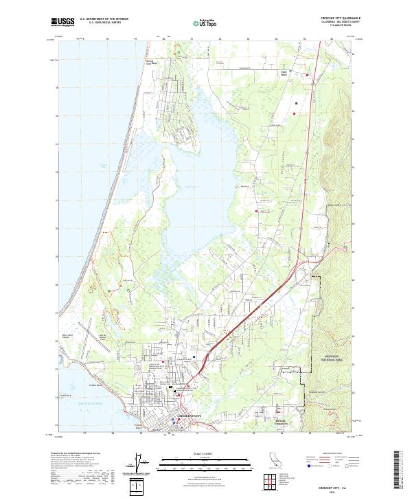 2021 Crescent City2021 Print · USGSCrescent City and the Del Norte coast appear in this detailed 2021 survey, from the redwood forests to the Pacific. Genealogists can locate Old County Cem and Saint Josephs Catholic Cem near Lake Talawa.
 - 2021 Map of Fern Canyon, 2021 Print
 2021 Fern Canyon2021 Print · USGSThe northern California coast is captured here in the early twenty-first century, showing the intersection of the Pacific Ocean and protected old-growth forests. You can trace the rugged geography of Fern Canyon, the sands of Gold Bluffs Beach, and the winding Newton B Drury Scenic Pkwy.
 - 2021 Map of Smith River, 2021 Print
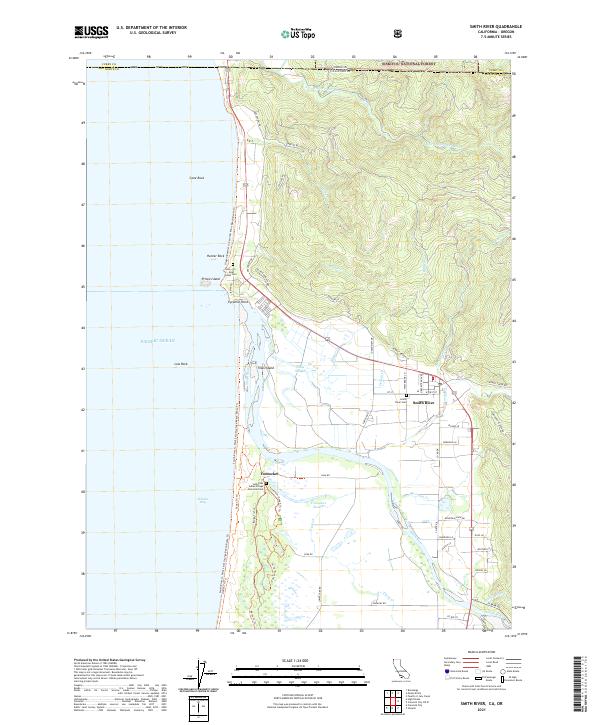 2021 Smith River2021 Print · USGSThe California-Oregon state line and the Pacific coastline meet in this contemporary look at a storied landscape. Local historians can trace indigenous heritage at the How-On Indian Cem and follow the Smith River through Tillas Island and Yontocket.
 - 2021 Map of Sister Rocks, 2021 Print
 2021 Sister Rocks2021 Print · USGSThe Del Norte coast near the turn of the decade shows the meeting of harbor industry and protected wilderness. Researchers can trace the shoreline from Crescent City down to Sister Rocks, identifying coastal landmarks like Battery Point and the trails of Redwood National Park.
 - 2021 Map of Hiouchi, 2021 Print
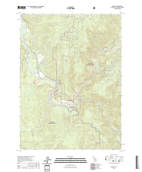 2021 Hiouchi2021 Print · USGSThe confluence of the Smith River's forks near Hiouchi is documented in this recent survey of Del Norte County's protected timberlands. Researchers can trace the boundaries of Redwood National Park and find specific access points like Douglas Park and Howland Hill Rd.
 - 2021 Map of Crescent City OE W, 2021 Print
 2021 Crescent City OE W2021 Print · USGSThe Del Norte coast is captured here in the early 2020s, showing the intricate network of seafloor hazards and channels off the California shoreline. Maritime researchers can trace the positioning of Saint George Reef, Dragon Channel, and the remote South West Seal Rock.
 - 2021 Map of High Divide, 2021 Print
 2021 High Divide2021 Print · USGSDel Norte County at the Oregon border is depicted here in the 2020s, showing the high-altitude interface of two national forests. Trace the historical ridge routes like Low Divide Road and locate remote points like Wimer Spring or Signal Peak.
 - 2021 Map of Chimney Rock, 2021 Print
 2021 Chimney Rock2021 Print · USGSThe Siskiyou Mountains and the headwaters of the Smith Wild and Scenic River are mapped here in the early 2020s. Hikers and researchers can trace the high-elevation routes of the Gasquet-Orleans road through Flint Valley and past the distinctive Chimney Rock.
 - 2021 Map of Ah Pah Ridge, 2021 Print
 2021 Ah Pah Ridge2021 Print · USGSThe Klamath River basin comes alive in this recent survey, showcasing the meeting point of national forests and parklands. Researchers can trace the winding course of the Klamath River past Starwein Flat and follow the routes of Ah Pah Rd and Cal Barrel Rd through the timber.
 - 2021 Map of Blue Creek Mountain, 2021 Print
 2021 Blue Creek Mountain2021 Print · USGSThe northern California mountains are captured here in a 2021 survey of the Humboldt and Del Norte county line. Researchers can trace the rugged forest roads and remote peaks that define the area, from South Red Mtn and Nickowitz Peak to the waters of Blue Creek.
 - 2022 Map of Klamath Glen, 2022 Print
 2022 Klamath Glen2022 Print · USGSThe lower Klamath River corridor is documented here in the early twenty-first century, showing the forest and river settlements of Del Norte County. Trace local geography from Klamath Glen to high-elevation points like Red Mtn and Cache Saddle.
 - 2022 Map of Prescott Mountain, 2022 Print
 2022 Prescott Mountain2022 Print · USGSIn the remote high country of the Siskiyou Mountains during the early 2020s, this area spans the intersection of two major national forests. Hikers and surveyors can trace the West Fork Clear Creek Trl or locate high-altitude waters like Solitaire Lake and Harrington Lake.
 - 2022 Map of Summit Valley, 2022 Print
 2022 Summit Valley2022 Print · USGSWithin the Klamath Mountains in the early 2020s, this area shows the protected wilderness of the Six Rivers National Forest. Researchers can trace remote routes like Gasquet-Orleans past landmarks such as Doctor Rock and Summit Valley.
 - 2022 Map of High Plateau Mountain, 2022 Print
 2022 High Plateau Mountain2022 Print · USGSThe California-Oregon state line runs through this mountain interior during the early 2020s, showing a landscape defined by protected forests and steep drainages. Researchers can trace historic access routes like Holiday Mine Road and Low Divide Road across Elk Camp Ridge.
 - 2022 Map of Devils Punchbowl, 2022 Print
 2022 Devils Punchbowl2022 Print · USGSDel Norte and Siskiyou counties are mapped here at the height of their modern wilderness designation, showcasing the divide between two national forests. Trace remote backcountry routes like the Devil's Punchbowl Trl to landmarks including Bear Mtn and Island Lake.
 - 2022 Map of Shelly Creek Ridge, 2022 Print
 2022 Shelly Creek Ridge2022 Print · USGSThe California-Oregon border country in the early twenty-first century reveals a rugged network of forest ridges and river flats. Researchers can trace the path of the Old Gasquet Toll Road and locate specific sites like Patrick Creek, Idlewild, and Washington Flat.
 - 2022 Map of Bark Shanty Gulch, 2022 Print
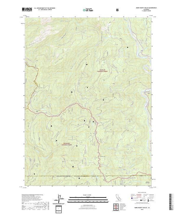 2022 Bark Shanty Gulch2022 Print · USGSSiskiyou County's high wilderness is documented here as the Klamath and Six Rivers forests intersect in the early 2020s. Researchers can trace the winding Gasquet-Orleans corridor past Lightning Ridge, Maple Spring, and the Klamath River.
 - 2022 Map of Canthook Mountain, 2022 Print
 2022 Canthook Mountain2022 Print · USGSThe Del Norte wilderness comes into focus in this recent survey of the ridges and riverbars within the Six Rivers National Forest. Researchers can trace the drainage of the South Fork Smith River and locate remote landmarks like Pigeon Roost Spring and Indian Bar.
 - 2022 Map of Gasquet, 2022 Print
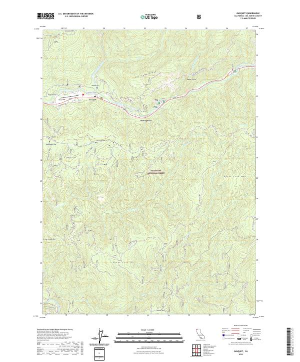 2022 Gasquet2022 Print · USGSThe Middle Fork of the Smith River flows through Del Norte County in the early 2020s, anchoring mountain communities like Gasquet. Researchers can trace the legacy of early transit along the Old Gasquet Toll Road or locate the Gasquet Cem and Ward Field.
 - 2022 Map of Lonesome Ridge, 2022 Print
 2022 Lonesome Ridge2022 Print · USGSThe high ridges of the California borderlands are captured here in the early 2020s, showing the intersection of three counties and two National Forests. Researchers can trace remote landmarks like Onion Lake, Laird Meadow, and the high-elevation lookout at Onion Mtn.
 - 2022 Map of Hurdygurdy Butte, 2022 Print
 2022 Hurdygurdy Butte2022 Print · USGSDel Norte County's high ridges and river canyons are preserved here during the early twenty-first century. Genealogists and local historians can trace the paths of Big Flat Road and locate landmarks like Hurdygurdy Butte and Patrick Creek.
 - 2022 Map of Ship Mountain, 2022 Print
 2022 Ship Mountain2022 Print · USGSThe northern reaches of the Six Rivers National Forest come into focus in this recent survey. Researchers can trace the winding Smith Wild and Scenic River past Blackhawk Bar or locate high-country features like Ship Mtn and Four Brothers.
Showing maps 1-25 of 28
Top cities of Del Norte County
Frequently asked questions
- What are the different types of historical maps available for Del Norte County?
- What is the oldest map of Del Norte County?
- Where can I purchase historical maps of Del Norte County for my home or office?
- Where can I download high-res historical maps of Del Norte County?
- Are there historical topographic maps available for Del Norte County?
- Is there historical aerial imagery available for Del Norte County?
- Where are historical maps of Del Norte County sourced from?