1950s Maps of Del Norte County, California
Explore 20 historic maps of Del Norte County from the 1950s. These maps offer a rare glimpse into what life looked like during the 1950s — showing old roads, neighborhoods, homes, and landmarks that have changed or disappeared over time.
Whether you're researching your family's past, planning a metal detecting trip, or studying how Del Norte County's landscape evolved across the 1950s, these high-resolution maps are a powerful tool for exploring the history of this region.
- Focus on a specific era: All maps on this page are from the 1950s, giving you a focused view of this time period.
- See what’s changed: Compare century-old streets, trails, and buildings to today's modern landscape using overlays and satellite layers.
- Research with precision: Use these maps for genealogy, historical research, land use analysis, or educational projects.
- View, download, or print: Maps are fully viewable online in high resolution, and can be downloaded or printed for your own records.
Start exploring Del Norte County's history through authentic maps from the 1950s. This is your window into the past.
Del Norte County, CA maps
(20)- 1950 Map of Weed
 1950 Weed1950 Print · USGSSiskiyou County and the surrounding Klamath mountains appear in the mid-century before extensive modern development. Genealogists and local historians can locate remote outposts like the Lee Brown Ranch and the specialized settlement of Darlingtonia.
 - 1951 Map of Gasquet, 1953 Print
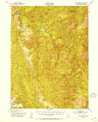
 1951 Gasquet1953 Print · USGSDel Norte County's rugged mining and timber country is captured here during the early fifties, centering on the Smith River corridor. Genealogists and researchers can trace local operations like the Morrell Placer Mine, locate remote outposts like Elk Camp, and find early settlements at Gasquet and Darlingtonia.5 unique versions available
 - 1952 Map of Orick, 1954 Print
 1952 Orick1954 Print · USGSThe northern California coast and its redwood forests appear here in the early fifties, centering on the valley of Redwood Creek. Local historians can trace the foundations of the park system and early settlements like Orick, Hufford Ranch, and the State Fish Hatchery.2 unique versions available
 - 1952 Map of Ship Mountain, 1954 Print
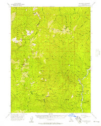
 1952 Ship Mountain1954 Print · USGSThe Del Norte backcountry in the early fifties shows a remote landscape of forest lookouts and riverside ranching. Genealogists and historians can trace isolated family outposts like Wilson Ranch and Alma Ranch or locate early forest camps such as Marlow Camp.3 unique versions available
 - 1952 Map of Klamath, 1954 Print
 1952 Klamath1954 Print · USGSThe Del Norte coast comes alive in the early fifties, showing the rugged interface between the redwoods and the Pacific. Trace the river economy near the Klamath River through landmarks like the Veneer Mill, Requa Sch, and the Douglas Mem Bridge.3 unique versions available
 - 1952 Map of Orleans, 1954 Print
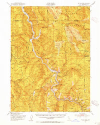
 1952 Orleans1954 Print · USGSThe Klamath River corridor near the tri-county border appears here in the early fifties, showing a landscape of forest service outposts and family ranching. Researchers can locate the Reece Homestead, the Hunter Little Ranch, and historical mining sites like the Owl Mine.3 unique versions available
 - 1952 Map of Tectah Creek, 1954 Print
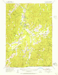
 1952 Tectah Creek1954 Print · USGSThe Klamath River corridor in the early fifties shows a landscape of river-dependent settlements and isolated mountain ranches. Genealogists and researchers can locate Mc Covey Ranch, the Pecwan Union School, and riverside points like Johnsons.3 unique versions available
 - 1952 Map of Crescent City, 1954 Print
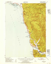
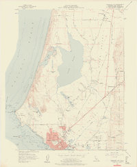
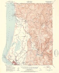 1952 Crescent City1954 Print · USGSCoastal Del Norte County appears here in the early fifties, from the Oregon border down to the streets of Crescent City. Genealogists and historians can trace indigenous sites like Yontocket and the Indian Cemetery or locate old operations like the Lind Mine.4 unique versions available
 - 1954 Map of Cave Junction, 1956 Print
 1954 Cave Junction1956 Print · USGSThe Illinois River valley in Southern Oregon comes alive in the mid-fifties, showing a landscape of mining camps and timber towns before modern development. Researchers can trace family sites at Takilma, locate the old Waldo townsite, or find historic workings like the Esterly Mine.3 unique versions available
 - 1955 Map of Dillon Mtn, 1957 Print
 1955 Dillon Mtn1957 Print · USGSNorthern California’s high country near the Klamath River is captured here in the mid-fifties. Genealogists and local historians can locate remote landmarks like the Kennedy Homestead, Cottage Grove, and the old Ti Bar School.3 unique versions available
 - 1955 Map of Medford, 1964 Print
 1955 Medford1964 Print · USGSSouthern Oregon's valley towns and high peaks are captured here in the mid-1950s, showing the region before the completion of the modern interstate system. Genealogists and historians can trace the development of timber and mining outposts from Wolf Creek to Butte Falls and the early roads to Crater Lake.3 unique versions available
 - 1956 Map of Sister Rocks, 1957 Print
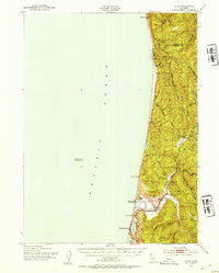
 1956 Sister Rocks1957 Print · USGSThe Del Norte coast in the mid-fifties shows the busy harbor at Crescent City transitioning into the wild forests of the Del Norte Coast Redwoods State Park. Trace the early maritime infrastructure at Citizens Dock or locate named offshore hazards like Sister Rocks and Fauntleroy Rock.
 - 1956 Map of Crescent City, 1957 Print
 1956 Crescent City1957 Print · USGSThe Northern California coast comes alive in this mid-fifties survey of the timber and ranching country around Crescent City. Researchers can trace the layout of the Crescent City Indian Res, find several rural Lumber Mill sites, and locate early schools like Redwood Union School.2 unique versions available
 - 1956 Map of Smith River, 1957 Print
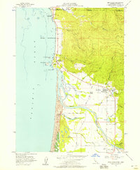 1956 Smith River1957 Print · USGSThe Smith River estuary and the rugged Del Norte coast come alive in this mid-century survey of the California-Oregon border. Genealogists and historians can trace family-named roads like Bailey Road or locate the Yontocket (Indian Village) Site and local industry at the Lumber Mill.2 unique versions available
 - 1956 Map of Preston Peak, 1958 Print
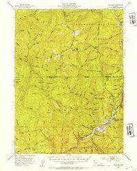
 1956 Preston Peak1958 Print · USGSThe high wilderness of the Siskiyou and Klamath ranges is captured here in the mid-fifties, centered on the heights of Preston Peak. Researchers can locate remote high-country sites like Porters Camp, Prescott Cabin, and the mineral prospects near Poker Flat.2 unique versions available
 - 1957 Map of Medford
 1957 Medford1957 Print · USGSSouthern Oregon during the mid-fifties is captured here as a region of growing valley cities and vast timberlands. Genealogists and historians can trace the rail-and-road corridors connecting Medford, Jacksonville, and Grants Pass to more remote locales like Wolf Creek or Butte Falls.
 - 1958 Map of Medford
 1958 Medford1958 Print · USGSSouthern Oregon's Rogue River valley thrived in the 1950s as a crossroads of rail and road. Researchers can trace the legacy of timber and tourism through Southern Pacific RR lines and landmarks like Crater Lake and Oregon Caves National Monument.
 - 1958 Map of Weed, 1963 Print
 1958 Weed1963 Print · USGSThe Northern California high country of the late fifties is defined by the towering presence of Mt Shasta and the logging railroads of the Siskiyou range. Genealogists and researchers can trace remote mining sites like the China Mine and mountain settlements such as Sawyers Bar and Seiad Valley.3 unique versions available
 - 1958 Map of Eureka, 1967 Print
 1958 Eureka1967 Print · USGSNorthern California's rugged redwood coast and timber corridors are captured in the late fifties, from the Oregon border down to Shelter Cove. Researchers can trace the path of the Northwestern Pacific railroad and locate rural landmarks like Grizzly Bluff School or the St Josephs Sch.
 - 1958 Map of Crescent City, 1978 Print
 1958 Crescent City1978 Print · USGSThe northwestern California coast and the Oregon borderlands are shown here during a period of expanding redwood conservation and active military presence. Researchers can trace historic sites from the Yontocket Indian Village Site to Fort Dick and the Klamath Air Force Station.
End of results
Showing maps 1-20 of 20
Top cities of Del Norte County
Frequently asked questions
- What are the different types of historical maps available for Del Norte County?
- What is the oldest map of Del Norte County?
- Where can I purchase historical maps of Del Norte County for my home or office?
- Where can I download high-res historical maps of Del Norte County?
- Are there historical topographic maps available for Del Norte County?
- Is there historical aerial imagery available for Del Norte County?
- Where are historical maps of Del Norte County sourced from?