1990s Maps of Del Norte County, California
Explore 22 historic maps of Del Norte County from the 1990s. These maps offer a rare glimpse into what life looked like during the 1990s — showing old roads, neighborhoods, homes, and landmarks that have changed or disappeared over time.
Whether you're researching your family's past, planning a metal detecting trip, or studying how Del Norte County's landscape evolved across the 1990s, these high-resolution maps are a powerful tool for exploring the history of this region.
- Focus on a specific era: All maps on this page are from the 1990s, giving you a focused view of this time period.
- See what’s changed: Compare century-old streets, trails, and buildings to today's modern landscape using overlays and satellite layers.
- Research with precision: Use these maps for genealogy, historical research, land use analysis, or educational projects.
- View, download, or print: Maps are fully viewable online in high resolution, and can be downloaded or printed for your own records.
Start exploring Del Norte County's history through authentic maps from the 1990s. This is your window into the past.
Del Norte County, CA maps
(22)- 1996 Map of Smith River, 1999 Print
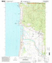 1996 Smith River1999 Print · USGSCoastal Del Norte County meets the Oregon border in the 1990s, where the river mouth creates a unique landscape of sloughs and dunes. Researchers can trace tribal heritage at the Yontocket Indian Village Site or explore local junctions like Winton Corners and Tryon Corner.
 - 1996 Map of Polar Bear Mountain, 1999 Print
 1996 Polar Bear Mountain1999 Print · USGSThe high Siskiyou crests at the turn of the millennium show a landscape of remote wilderness and early mining claims. Trace historical backcountry sites like Offield Mine, Porters Camp, and the high-elevation basin at Poker Flat.
 - 1996 Map of Takilma, 1999 Print
 1996 Takilma1999 Print · USGSMining and timber define the Illinois Valley in the late twentieth century as it straddles the California border. Historians can trace extraction sites like the Queen of Bronze Mine and Ponyhoe Mine or locate the historic Browntown (Site).
 - 1996 Map of Broken Rib Mountain, 1999 Print
 1996 Broken Rib Mountain1999 Print · USGSThe Klamath Mountains straddle the California-Oregon border in the mid-nineties, capturing a landscape of steep peaks and protected river corridors. Researchers can find old mining prospects, the high-altitude Sanger Peak, and the historic Camp Chicago (Site).
 - 1997 Map of Requa, 2001 Print
 1997 Requa2001 Print · USGSThe Klamath River estuary in the late 1990s reveals a unique landscape where tribal reservations and national parks meet the Pacific. Researchers can trace local history at the Requa Cem, the Keating School, and the Klamath Air Force Station.
 - 1997 Map of Summit Valley, 2001 Print
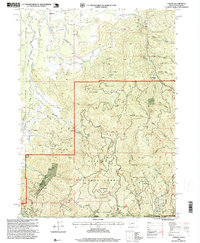
 1997 Summit Valley2001 Print · USGSDel Norte County's high wilderness is surveyed here in the late nineties, showcasing the intersection of national forest and recreation lands. Trace the remote locations of the Summit Valley Lookout, the high point of Doctor Rock, and a local Quarry.
 - 1997 Map of Chimney Rock, 2001 Print
 1997 Chimney Rock2001 Print · USGSThe high Siskiyou backcountry of Del Norte and Siskiyou counties is captured here in the late nineties as a dense network of wilderness and national forest lands. Researchers can locate the Siskiyou Mine, former camps at Rose Camp, and landmarks like Chimney Rock.
 - 1997 Map of Lonesome Ridge, 2001 Print
 1997 Lonesome Ridge2001 Print · USGSThe high ridges and deep gulches of the tri-county border area are captured here in the late nineties. Local researchers can trace old camps and remote water sources like Loose Camp, Onion Lake, and the high-elevation Laird Meadow.
 - 1997 Map of High Divide, 2001 Print
 1997 High Divide2001 Print · USGSThe Siskiyou and Six Rivers forests meet at the turn of the millennium along the wild California-Oregon border. You can trace early mountain transit and extraction history through the Wimer Road and sites like the Mountain View Mines or the Stone Corral (Site).
 - 1997 Map of Shelly Creek Ridge, 2001 Print
 1997 Shelly Creek Ridge2001 Print · USGSThe Smith River canyons and Siskiyou Mountains were a hub for early transit and prospectors during the late twentieth century. Trace the path of the Old Gasquet Toll Road or locate historical mineral sites like the Holiday Mine and Monumental (Site).
 - 1997 Map of Hiouchi, 2001 Print
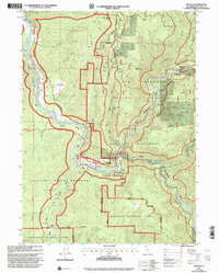 1997 Hiouchi2001 Print · USGSDel Norte County at the close of the twentieth century shows a landscape where protected redwood groves meet the wild forks of the Smith River. Researchers can locate historical sites like Nickerson Ranch (Site) or trace river landings from Myrtle Camp to Stout Grove.
 - 1997 Map of Devils Punchbowl, 2001 Print
 1997 Devils Punchbowl2001 Print · USGSThe Klamath Mountains in the late nineties are shown here at the meeting point of three major forest preserves. Researchers can trace the high-country geography of Devils Punchbowl and remote outposts like Lookout Pierson Cabin and Trout Camp.
 - 1997 Map of Blue Creek Mountain, 2001 Print
 1997 Blue Creek Mountain2001 Print · USGSHumboldt and Del Norte counties meet at this high-altitude wilderness boundary in the late nineties. Researchers can trace the remote drainage of Blue Creek and locate landmarks like Bear Pen Flat and the peaks along Lookout Point Ridge.
 - 1997 Map of Cant Hook Mountain, 2001 Print
 1997 Cant Hook Mountain2001 Print · USGSThe South Fork Smith River corridor in the late nineties is documented here in detail, showing a landscape of forest management and early recreation. Trace historic activity through Prospects, Hurdygurdy Bridge, and Soldier Well.
 - 1997 Map of High Plateau Mountain, 2001 Print
 1997 High Plateau Mountain2001 Print · USGSThe California-Oregon border country was a remote mining and timber frontier during the late twentieth century. Researchers can trace historic extraction sites like the Cleopatra Mine, Browns Mine, and the Big Boy Mine tucked into the rugged slopes of High Plateau Mountain.
 - 1997 Map of Klamath Glen, 2001 Print
 1997 Klamath Glen2001 Print · USGSKlamath Glen and the Hoopa Valley Indian Reservation appear in the late nineties as a landscape of timber and river access. Genealogists and historians can trace riverside life at Klamath Glen and find remote sites like the Marlow Campsite and Starwein Flat.
 - 1997 Map of Ship Mountain, 2001 Print
 1997 Ship Mountain2001 Print · USGSNorthern California's Siskiyou Mountains are shown in the late nineties, featuring a network of protected wilderness and national forest lands. Researchers can trace historic routes like the Kelsey Trail or locate remote landmarks like the Buck Creek Shelter and Muslatt Lake.
 - 1997 Map of Hurdygurdy Butte, 2001 Print
 1997 Hurdygurdy Butte2001 Print · USGSThe Del Norte backcountry near the turn of the millennium was a landscape of deep river canyons and rugged ridges. Researchers can trace historic access via the Gasquet Toll Road and locate remote landmarks like Pea Vine Lake or the Upper Coon Mtn Shelter.
 - 1997 Map of Prescott Mountain, 2001 Print
 1997 Prescott Mountain2001 Print · USGSSiskiyou and Del Norte counties met here in the late nineties, where the high ridges of the Klamath Mountains transition between national forests. Hikers and researchers can trace the routes to the Bear Wallows Shelter, Prescott Lake, and Harrington Lake.
 - 1997 Map of Gasquet, 2001 Print
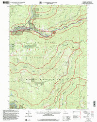 1997 Gasquet2001 Print · USGSThe confluence of the Smith River forks in Northern California was a center of mountain life and resource extraction in the late nineties. Local researchers can trace old routes like the Old Gasquet Toll Road and locate the Tyson Chrome Mine and Gasquet Mountain School.
 - 1997 Map of Ah Pah Ridge, 2001 Print
 1997 Ah Pah Ridge2001 Print · USGSThe Klamath River corridor in the late nineties showcases a complex meeting of tribal lands and protected forests. Researchers can trace the river's winding path past the McCovey Ranch and the Blue Creek Lodge (Site) within the Hoopa Valley Indian Reservation.
 - 1997 Map of Childs Hill, 2001 Print
 1997 Childs Hill2001 Print · USGSCoastal Del Norte County is shown in the late nineties as a convergence of vast protected parklands and wild river systems. Researchers can trace the complex watersheds of Mill Creek and the East Fork Smith River or locate remote landmarks like Bummer Lake and Childs Hill.
End of results
Showing maps 1-22 of 22
Top cities of Del Norte County
Frequently asked questions
- What are the different types of historical maps available for Del Norte County?
- What is the oldest map of Del Norte County?
- Where can I purchase historical maps of Del Norte County for my home or office?
- Where can I download high-res historical maps of Del Norte County?
- Are there historical topographic maps available for Del Norte County?
- Is there historical aerial imagery available for Del Norte County?
- Where are historical maps of Del Norte County sourced from?