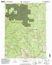
1996 Map of Broken Rib Mountain
USGS Topo · Published 1999About this map
Broken Rib Mountain dominates this rugged wilderness corridor in the late 1990s, where the Siskiyou National Forest and Six Rivers National Forest meet at the California-Oregon state line. The landscape is defined by the steep drainages of the Middle Fork Smith River and the Illinois River, which provide the hydrological framework for this protected mountain terrain. Human activity is concentrated near the Randolph Collier Tunnel and the Collier Roadside Rest along the western edge, while the interior remains a vast roadless area accessible primarily by trails. Significant landmarks for local history and topography include Sanger Peak, Youngs Valley, and the archaeological footprint of Camp Chicago (Site). The map details several scattered prospects and mines, indicating a legacy of resource exploration that predates the modern designations of the Siskiyou Wilderness and the Smith River National Recreation Area.
Find a feature on this map
44 named features on this map. Tap any name to fly to it.
Don’t see what you’re looking for? This feature index may not catch every label — zoom into the map to look around manually.
Map Details
Editions of this 1996 Broken Rib Mountain Map
This is the sole edition of this map. No revisions or reprints were ever made.
Other maps of this area

1917 · Kerby
USGS Topo · 1:125,000

1918 · Kerby
USGS Topo · 1:125,000

1922 · Preston Peak
USGS Topo · 1:125,000

1945 · Kerby
USGS Topo · 1:125,000

1945 · Gasquet
USGS Topo · 1:62,500

1948 · Weed
USGS Topo · 1:250,000

1950 · Weed
USGS Topo · 1:250,000

1951 · Gasquet
USGS Topo · 1:62,500

1954 · Cave Junction
USGS Topo · 1:62,500

1954 · Chetco Peak
USGS Topo · 1:62,500