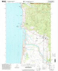
1996 Map of Smith River
USGS Topo · Published 1999About this map
The Smith River corridor and its surrounding coastal plains define this late-20th-century landscape at the edge of the California-Oregon border. This area is deeply tied to indigenous heritage, as shown by the Yontocket Indian Village Site, the Indian Cemetery, and the Smith River Rancheria. These sites sit near the mouth of the river, where shifting Sand Dunes and the Tillas Slough create a complex marshland environment between the rugged coastline and the rising foothills of the Siskiyou National Forest.
Find a feature on this map
42 named features on this map. Tap any name to fly to it.
Don’t see what you’re looking for? This feature index may not catch every label — zoom into the map to look around manually.
Map Details
Editions of this 1996 Smith River Map
This is the sole edition of this map. No revisions or reprints were ever made.
Other maps of this area

1929 · Crescent City
USGS Topo · 1:125,000

1945 · Point St. George
USGS Topo · 1:62,500

1949 · Eureka
USGS Topo · 1:250,000

1952 · Crescent City
USGS Topo · 1:62,500

1954 · Coos Bay
USGS Topo · 1:250,000

1954 · Cape Ferrelo
USGS Topo · 1:62,500

1954 · Mt. Emily
USGS Topo · 1:62,500

1956 · Crescent City
USGS Topo · 1:24,000

1956 · Smith River
USGS Topo · 1:24,000

1958 · Eureka
USGS Topo · 1:250,000