
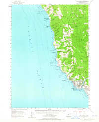
1954 Map of Cape Ferrelo
USGS Topo · Published 1956About this map
The Chetco River meets the Pacific Ocean at the southern edge of this mid-century survey, anchoring the growing community of Brookings and the adjacent settlement of Harbor. This coastal corridor is defined by a succession of protected landscapes, most notably the expansive Samuel H Boardman State Park, which preserves the dramatic interface of headlands and sea stacks. Inland, the terrain rises sharply into the Siskiyou National Forest, a region of steep ridges and deep drainages like Thomas Creek and Mayfield Creek. The map documents the localized development around Carpenterville and the coastal clusters at Whalehead and Cape Ferrelo. Notable landmarks along the surf line include the distinctive Mack Arch and Goat Island, providing a detailed look at the Curry County coastline before modern expansion reshaped the access points along the bluff.
Find a feature on this map
65 named features on this map. Tap any name to fly to it.
Don’t see what you’re looking for? This feature index may not catch every label — zoom into the map to look around manually.
Map Details
Editions of this 1954 Cape Ferrelo Map
2 editions found
Other maps of this area

1929 · Crescent City
USGS Topo · 1:125,000

1945 · Point St. George
USGS Topo · 1:62,500

1949 · Eureka
USGS Topo · 1:250,000

1952 · Crescent City
USGS Topo · 1:62,500

1954 · Coos Bay
USGS Topo · 1:250,000

1954 · Gold Beach
USGS Topo · 1:62,500

1954 · Collier Butte
USGS Topo · 1:62,500

1954 · Mt. Emily
USGS Topo · 1:62,500

1956 · Smith River
USGS Topo · 1:24,000

1958 · Eureka
USGS Topo · 1:250,000