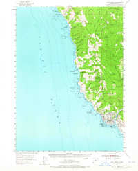
1954 Map of Cape Ferrelo
USGS Topo · Published 1965About this map
Brookings and Harbor anchor the southern coastline of Curry County where the Chetco River meets the Pacific Ocean. This 1954 survey captures the coastal development along Highway 101 and the rugged interior defined by the Siskiyou National Forest. The landscape is a transition between the dense forest and the rocky Pacific shore, featuring prominent landmarks like Cape Ferrelo and Goat Island. Significant recreation areas including Harris Beach State Park and Azalea State Park are established here, while the northern reaches show smaller settlements like Carpenterville and Thomas. The mapping of Numerous creeks, such as Whalehead Creek and Spruce Creek, illustrates the drainage patterns from high points like Hog Mtn and Mt Italy toward the sea.
Find a feature on this map
73 named features on this map. Tap any name to fly to it.
Don’t see what you’re looking for? This feature index may not catch every label — zoom into the map to look around manually.
Map Details
Editions of this 1954 Cape Ferrelo Map
2 editions found
Other maps of this area

1929 · Crescent City
USGS Topo · 1:125,000

1945 · Point St. George
USGS Topo · 1:62,500

1949 · Eureka
USGS Topo · 1:250,000

1952 · Crescent City
USGS Topo · 1:62,500

1954 · Coos Bay
USGS Topo · 1:250,000

1954 · Cape Ferrelo
USGS Topo · 1:62,500

1954 · Gold Beach
USGS Topo · 1:62,500

1954 · Collier Butte
USGS Topo · 1:62,500

1954 · Mt. Emily
USGS Topo · 1:62,500

1956 · Smith River
USGS Topo · 1:24,000