
1956 Map of Smith River
USGS Topo · Published 1957About this map
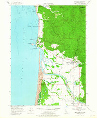
The Smith River estuary and the rugged coastline near the Oregon-California border define this coastal landscape in the mid-1950s. The map highlights the indigenous history of the region, specifically marking the Yontocket (Indian Village) Site and the Smith River Indian Reservation near the rocky shores of Pyramid Point. The local economy of the time is visible through several Lumber Mill operations and a Millpond (Aban'd) east of the main settlement.
Find a feature on this map
52 named features on this map. Tap any name to fly to it.
Don’t see what you’re looking for? This feature index may not catch every label — zoom into the map to look around manually.
Map Details
Editions of this 1956 Smith River Map
2 editions found
Other maps of this area

1929 · Crescent City
USGS Topo · 1:125,000

1945 · Point St. George
USGS Topo · 1:62,500

1949 · Eureka
USGS Topo · 1:250,000

1952 · Crescent City
USGS Topo · 1:62,500

1954 · Coos Bay
USGS Topo · 1:250,000

1954 · Cape Ferrelo
USGS Topo · 1:62,500

1954 · Mt. Emily
USGS Topo · 1:62,500

1956 · Crescent City
USGS Topo · 1:24,000

1958 · Eureka
USGS Topo · 1:250,000

1958 · Coos Bay
USGS Topo · 1:250,000