
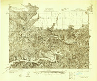
1958 Map of Coos Bay
USGS Topo · Published 1974About this map
The Siuslaw National Forest and Siskiyou National Forest define the heavily timbered interior of the Southern Oregon coast in this mid-century survey. Heavy industrial development and maritime trade are centered on the deep-water port of Coos Bay and adjacent North Bend, where the Southern Pacific RR connects coastal lumber interests to the broader rail network. The map illustrates a landscape of high coastal promontories and river estuaries, from Cape Blanco near Denmark to the mouth of the Rogue River at Gold Beach. Smaller agricultural and logging hubs like Coquille, Myrtle Point, and Powers are linked by Route 42, while the iconic Highway 101 serves as the primary coastal artery connecting Port Orford to northern settlements like Florence and Reedsport.
Find a feature on this map
78 named features on this map. Tap any name to fly to it.
Don’t see what you’re looking for? This feature index may not catch every label — zoom into the map to look around manually.
Map Details
Editions of this 1958 Coos Bay Map
This is the sole edition of this map. No revisions or reprints were ever made.
Other maps of this area

1896 · Coos Bay
USGS Topo · 1:125,000

1898 · Coos Bay
USGS Topo · 1:125,000

1899 · Port Orford
USGS Topo · 1:125,000

1900 · Coos Bay
USGS Topo · 1:125,000

1903 · Port Orford
USGS Topo · 1:125,000

1917 · Kerby
USGS Topo · 1:125,000

1918 · Kerby
USGS Topo · 1:125,000
1918 · Mapleton
USGS Topo · 1:48,000

1919 · Earl
USGS Topo · 1:48,000
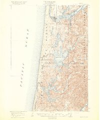
1920 · Siltcoos Lake
USGS Topo · 1:62,500