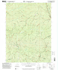
1997 Map of Lonesome Ridge
USGS Topo · Published 2001About this map
Lonesome Ridge bisects this remote landscape at the meeting point of Del Norte, Siskiyou, and Humboldt counties. Compiled from 1970s topography and updated with 1990s imagery, the map documents a rugged wilderness dominated by the Siskiyou Wilderness and Six Rivers National Forest. Small pockets of human presence appear at Laird Meadow and Loose Camp, while a Quarry and the Go-Road indicate the industrial and infrastructural reach into these high elevations. The drainage patterns are meticulously recorded, showing the East Fork Blue Creek and Bluff Creek systems carving through the terrain. High-altitude water bodies like Onion Lake, Deer Lick Lake, and Siskiyou Pond provide specific points of interest for those tracing the historical geography of this tri-county border region.
Find a feature on this map
31 named features on this map. Tap any name to fly to it.
Don’t see what you’re looking for? This feature index may not catch every label — zoom into the map to look around manually.
Map Details
Editions of this 1997 Lonesome Ridge Map
This is the sole edition of this map. No revisions or reprints were ever made.
Other maps of this area

1922 · Preston Peak
USGS Topo · 1:125,000

1925 · Hoopa
USGS Topo · 1:125,000

1945 · Ship Mountain
USGS Topo · 1:62,500

1945 · Tectah Creek
USGS Topo · 1:62,500

1948 · Weed
USGS Topo · 1:250,000

1950 · Weed
USGS Topo · 1:250,000

1952 · Ship Mountain
USGS Topo · 1:62,500

1952 · Orleans
USGS Topo · 1:62,500

1952 · Tectah Creek
USGS Topo · 1:62,500

1955 · Dillon Mtn
USGS Topo · 1:62,500