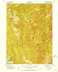
1952 Map of Ship Mountain
USGS Topo · Published 1954About this map
The South Fork Smith River and the Klamath River anchor this mid-century view of the wild Del Norte interior. The landscape is defined by the convergence of the Siskiyou National Forest, Klamath National Forest, and Six Rivers National Forest, where a network of lookouts like Lookout No 1 and Lookout No 2 monitored the timberlands. Early habitation is visible through remote outposts such as Wilson Ranch, Guys Ranch, and the Knapp Estate, while industrial activity is noted at the Chrome Mine (Ora Grande). Historical access to these deep canyons relied on landmarks like the Hurdygurdy Bridge and the Elkhorn Bar Trail. The presence of several backcountry sites, including Marlow Camp and Big Flat Guard Sta, illustrates the era's reliance on stationary forest management stations and isolated riverside ranching before modern road expansion.
Find a feature on this map
81 named features on this map. Tap any name to fly to it.
Don’t see what you’re looking for? This feature index may not catch every label — zoom into the map to look around manually.
Map Details
Editions of this 1952 Ship Mountain Map
3 editions found
Historical Maps of Peak Eight Through Time
113 maps found

1922 Preston Peak
Del Norte County, CA

1945 Point St. George
Del Norte County, CA

1945 Requa
Del Norte County, CA

1945 Ship Mountain
Del Norte County, CA

1952 Ship Mountain
Del Norte County, CA

1956 Preston Peak
Del Norte County, CA

1956 Sister Rocks
Del Norte County, CA

1966 Childs Hill
Del Norte County, CA

1966 High Divide
Del Norte County, CA

1966 Requa
Del Norte County, CA

1966 Sister Rocks
Del Norte County, CA

1974 Lonesome Ridge
Del Norte County, CA

1975 Gasquet NW
Del Norte County, CA

1981 Chimney Rock
Del Norte County, CA

1981 Devils Punchbowl
Del Norte County, CA

1981 Prescott Mountain
Del Norte County, CA

1981 Summit Valley
Del Norte County, CA

1982 Broken Rib Mtn
Del Norte County, CA

1982 Cant Hook Mtn
Del Norte County, CA

1982 High Plateau Mtn.
Del Norte County, CA

1982 Hurdygurdy Butte
Del Norte County, CA

1982 Klamath Glen
Del Norte County, CA

1982 Polar Bear Mountain
Del Norte County, CA

1982 Shelly Creek Ridge
Del Norte County, CA

1982 Ship Mountain
Del Norte County, CA

1996 Broken Rib Mountain
Del Norte County, CA

1996 Polar Bear Mountain
Del Norte County, CA

1997 Cant Hook Mountain
Del Norte County, CA

1997 Childs Hill
Del Norte County, CA

1997 Chimney Rock
Del Norte County, CA

1997 Devils Punchbowl
Del Norte County, CA

1997 High Divide
Del Norte County, CA

1997 High Plateau Mountain
Del Norte County, CA

1997 Hurdygurdy Butte
Del Norte County, CA

1997 Klamath Glen
Del Norte County, CA

1997 Lonesome Ridge
Del Norte County, CA

1997 Prescott Mountain
Del Norte County, CA

1997 Requa
Del Norte County, CA

1997 Shelly Creek Ridge
Del Norte County, CA

1997 Ship Mountain
Del Norte County, CA

1997 Summit Valley
Del Norte County, CA

2012 Broken Rib Mountain
Del Norte County, CA

2012 Canthook Mountain
Del Norte County, CA

2012 Childs Hill
Del Norte County, CA

2012 Chimney Rock
Del Norte County, CA

2012 Crescent City OE W
Del Norte County, CA

2012 Devils Punchbowl
Del Norte County, CA

2012 High Divide
Del Norte County, CA

2012 High Plateau Mountain
Del Norte County, CA

2012 Hurdygurdy Butte
Del Norte County, CA

2012 Klamath Glen
Del Norte County, CA

2012 Lonesome Ridge
Del Norte County, CA

2012 Polar Bear Mountain
Del Norte County, CA

2012 Prescott Mountain
Del Norte County, CA

2012 Requa
Del Norte County, CA

2012 Shelly Creek Ridge
Del Norte County, CA

2012 Ship Mountain
Del Norte County, CA

2012 Sister Rocks
Del Norte County, CA

2012 Summit Valley
Del Norte County, CA

2015 Broken Rib Mountain
Del Norte County, CA

2015 Canthook Mountain
Del Norte County, CA

2015 Childs Hill
Del Norte County, CA

2015 Chimney Rock
Del Norte County, CA

2015 Crescent City OE W
Del Norte County, CA

2015 Devils Punchbowl
Del Norte County, CA

2015 High Divide
Del Norte County, CA

2015 High Plateau Mountain
Del Norte County, CA

2015 Hurdygurdy Butte
Del Norte County, CA

2015 Klamath Glen
Del Norte County, CA

2015 Lonesome Ridge
Del Norte County, CA

2015 Polar Bear Mountain
Del Norte County, CA

2015 Prescott Mountain
Del Norte County, CA

2015 Requa
Del Norte County, CA

2015 Shelly Creek Ridge
Del Norte County, CA

2015 Ship Mountain
Del Norte County, CA

2015 Sister Rocks
Del Norte County, CA

2015 Summit Valley
Del Norte County, CA

2018 Broken Rib Mountain
Del Norte County, CA

2018 Canthook Mountain
Del Norte County, CA

2018 Childs Hill
Del Norte County, CA

2018 Chimney Rock
Del Norte County, CA

2018 Crescent City OE W
Del Norte County, CA

2018 Devils Punchbowl
Del Norte County, CA

2018 High Divide
Del Norte County, CA

2018 High Plateau Mountain
Del Norte County, CA

2018 Hurdygurdy Butte
Del Norte County, CA

2018 Klamath Glen
Del Norte County, CA

2018 Lonesome Ridge
Del Norte County, CA

2018 Polar Bear Mountain
Del Norte County, CA

2018 Prescott Mountain
Del Norte County, CA

2018 Requa
Del Norte County, CA

2018 Shelly Creek Ridge
Del Norte County, CA

2018 Ship Mountain
Del Norte County, CA

2018 Sister Rocks
Del Norte County, CA

2018 Summit Valley
Del Norte County, CA

2021 Childs Hill
Del Norte County, CA

2021 Chimney Rock
Del Norte County, CA

2021 Crescent City OE W
Del Norte County, CA

2021 High Divide
Del Norte County, CA

2021 Requa
Del Norte County, CA

2021 Sister Rocks
Del Norte County, CA

2022 Broken Rib Mountain
Del Norte County, CA

2022 Canthook Mountain
Del Norte County, CA

2022 Devils Punchbowl
Del Norte County, CA

2022 High Plateau Mountain
Del Norte County, CA

2022 Hurdygurdy Butte
Del Norte County, CA

2022 Klamath Glen
Del Norte County, CA

2022 Lonesome Ridge
Del Norte County, CA

2022 Polar Bear Mountain
Del Norte County, CA

2022 Prescott Mountain
Del Norte County, CA

2022 Shelly Creek Ridge
Del Norte County, CA

2022 Ship Mountain
Del Norte County, CA

2022 Summit Valley
Del Norte County, CA