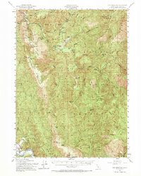
1952 Map of Ship Mountain
USGS Topo · Published 1970About this map
The remote interior of the Six Rivers National Forest is defined here by the confluence of the South Fork Smith River and the high ridges of the Klamath Mountains. In the early 1950s, this landscape supported small-scale mining operations and isolated ranching outposts. Landmarks such as the China Mine (Ora Grande) and a Chrome Mine point to the area’s geologic utility, while scattered family-named properties like Stevens Ranch, Wilson Ranch, and Alma Ranch indicate a sparse but persistent human presence in the river valleys. The southern edge of the survey reaches Klamath Glen near the Klamath River, where a Cem and Guys Ranch mark the transition toward more established settlements. Strategic infrastructure is visible through the Big Flat Guard Sta and a Lookout on a high peak, reflecting the essential role of fire oversight and land management in this heavily forested terrain.
Find a feature on this map
81 named features on this map. Tap any name to fly to it.
Don’t see what you’re looking for? This feature index may not catch every label — zoom into the map to look around manually.
Map Details
Editions of this 1952 Ship Mountain Map
3 editions found

Other maps of this area

1922 · Preston Peak
USGS Topo · 1:125,000

1925 · Hoopa
USGS Topo · 1:125,000

1929 · Crescent City
USGS Topo · 1:125,000

1945 · Ship Mountain
USGS Topo · 1:62,500

1945 · Orick
USGS Topo · 1:62,500

1945 · Gasquet
USGS Topo · 1:62,500

1945 · Point St. George
USGS Topo · 1:62,500

1945 · Requa
USGS Topo · 1:62,500

1945 · Tectah Creek
USGS Topo · 1:62,500

1948 · Weed
USGS Topo · 1:250,000