1900s (20th Century) Maps of Capay, California
Explore 8 historic maps of Capay from the 1900s (20th Century). These maps offer a rare glimpse into what life looked like during the 1900s — showing old roads, neighborhoods, homes, and landmarks that have changed or disappeared over time.
Whether you're researching your family's past, planning a metal detecting trip, or studying how Capay's landscape evolved across the 1900s, these high-resolution maps are a powerful tool for exploring the history of this region.
- Focus on a specific era: All maps on this page are from the 1900s, giving you a focused view of this time period.
- See what’s changed: Compare century-old streets, trails, and buildings to today's modern landscape using overlays and satellite layers.
- Research with precision: Use these maps for genealogy, historical research, land use analysis, or educational projects.
- View, download, or print: Maps are fully viewable online in high resolution, and can be downloaded or printed for your own records.
Start exploring Capay's history through authentic maps from the 1900s. This is your window into the past.
Capay, CA maps
(8)- 1904 Map of Vina
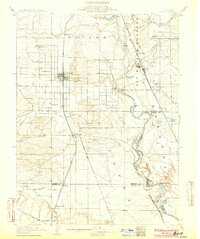 1904 Vina1904 Print · USGSThe Sacramento Valley comes alive in this early century study of the river corridor between Tehama and Butte counties. Trace the rail-and-river economy through the Winery at Vina, the Squaw Hill Ferry, and the planned Lemon Home Colony.3 unique versions available
 - 1914 Map of McIntosh Landing
 1914 McIntosh Landing1914 Print · USGSThe Sacramento River corridor north of Hamilton City is shown here in the early twentieth century as a complex landscape of shifting islands and landings. Trace the historic riverfront at McIntosh Landing or follow the path of the Central Irrigation Canal.
 - 1950 Map of Foster Island, 1963 Print
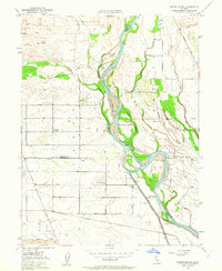 1950 Foster Island1963 Print · USGSThe Sacramento River valley at mid-century shows a landscape of river landings and evolving irrigation systems. Trace the location of former river hubs at Wilson Landing and McIntosh Ldg, or locate family landmarks like McIntosh Sch and Capay Sch.4 unique versions available
 - 1951 Map of Foster Island
 1951 Foster Island1951 Print · USGSThe Sacramento River valley in the early fifties is captured here as a landscape of river landings and organized farm blocks. Genealogists can trace family connections through named locations like Mcintosh Sch, Capay, and the historical Wilson Landing.
 - 1951 Map of Corning, 1959 Print
 1951 Corning1959 Print · USGSThe Sacramento Valley in the early fifties shows a region defined by its river landings and expanding rail infrastructure. Researchers can locate family-named schools and vanished river sites such as McIntosh Landing, Kirkwood Cemetery, and Union High School.3 unique versions available
 - 1957 Map of Ukiah, 1966 Print
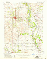
 1957 Ukiah1966 Print · USGSNorthern California's diverse terrain comes into focus in the mid-1950s, from the rugged timberlands of the Jackson State Forest to the productive Sacramento Valley. Genealogists and historians can trace the rail lines of the Northwestern Pacific or locate early valley settlements like Arbuckle and Paskenta.3 unique versions available
 - 1960 Map of Ukiah
 1960 Ukiah1960 Print · USGSNorthern California during the late fifties reveals a landscape of deep timber forests and valley agriculture before modern expansion. Trace the historic rail lines of the California Western RR and the Northwestern Pacific RR through settlements like Fort Bragg and Ukiah.2 unique versions available
 - 1987 Map of Willows, 1988 Print
 1987 Willows1988 Print · USGSThe northern Sacramento Valley meets the Coast Range in the late eighties, showing a landscape defined by water and transit. Researchers can trace the Southern Pacific railroad past Artois and Corning, or locate family-named landmarks like Larkins Childrens Rancho and Snaden Island.2 unique versions available
End of results
Showing maps 1-8 of 8
Top cities near Capay
- Chico historical maps
- Corning historical maps
- Durham historical maps
- Los Molinos historical maps
- Tehama historical maps
- Vina historical maps
Frequently asked questions
- What are the different types of historical maps available for Capay?
- What is the oldest map of Capay?
- Where can I purchase historical maps of Capay for my home or office?
- Where can I download high-res historical maps of Capay?
- Are there historical topographic maps available for Capay?
- Is there historical aerial imagery available for Capay?
- Where are historical maps of Capay sourced from?