1920s Maps of Arcata, California
Explore 2 historic maps of Arcata from the 1920s. These maps offer a rare glimpse into what life looked like during the 1920s — showing old roads, neighborhoods, homes, and landmarks that have changed or disappeared over time.
Whether you're researching your family's past, planning a metal detecting trip, or studying how Arcata's landscape evolved across the 1920s, these high-resolution maps are a powerful tool for exploring the history of this region.
- Focus on a specific era: All maps on this page are from the 1920s, giving you a focused view of this time period.
- See what’s changed: Compare century-old streets, trails, and buildings to today's modern landscape using overlays and satellite layers.
- Research with precision: Use these maps for genealogy, historical research, land use analysis, or educational projects.
- View, download, or print: Maps are fully viewable online in high resolution, and can be downloaded or printed for your own records.
Start exploring Arcata's history through authentic maps from the 1920s. This is your window into the past.
Arcata, CA maps
(2)- 1922 Map of Eureka
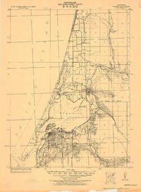 1922 Eureka1922 Print · USGSHumboldt Bay and the redwood coast are captured in the early twenties as the region’s timber and rail economy reached its height. Genealogists and historians can trace family-named settlements like John Brown and Wheeler, or locate industrial sites such as the Shingle Mill and the Arcata Wharf.
 - 1922 Map of Korbel
 1922 Korbel1922 Print · USGSHumboldt County’s timber and rail economy is on full display in the early 1920s as rail lines converge along the Mad River. Genealogists and historians can trace family-named outposts like Berry's, Bairs, and Murphy or follow the early tracks of the Arcata and Mad River Railroad.
End of results
Showing maps 1-2 of 2
Top cities near Arcata
- Eureka historical maps
- McKinleyville historical maps
- Blue Lake historical maps
- Loleta historical maps
- Trinidad historical maps
Top neighborhoods of Arcata
Frequently asked questions
- What are the different types of historical maps available for Arcata?
- What is the oldest map of Arcata?
- Where can I purchase historical maps of Arcata for my home or office?
- Where can I download high-res historical maps of Arcata?
- Are there historical topographic maps available for Arcata?
- Is there historical aerial imagery available for Arcata?
- Where are historical maps of Arcata sourced from?