1900s (20th Century) Maps of Beall Place, California
Explore 6 historic maps of Beall Place from the 1900s (20th Century). These maps offer a rare glimpse into what life looked like during the 1900s — showing old roads, neighborhoods, homes, and landmarks that have changed or disappeared over time.
Whether you're researching your family's past, planning a metal detecting trip, or studying how Beall Place's landscape evolved across the 1900s, these high-resolution maps are a powerful tool for exploring the history of this region.
- Focus on a specific era: All maps on this page are from the 1900s, giving you a focused view of this time period.
- See what’s changed: Compare century-old streets, trails, and buildings to today's modern landscape using overlays and satellite layers.
- Research with precision: Use these maps for genealogy, historical research, land use analysis, or educational projects.
- View, download, or print: Maps are fully viewable online in high resolution, and can be downloaded or printed for your own records.
Start exploring Beall Place's history through authentic maps from the 1900s. This is your window into the past.
Beall Place, CA maps
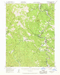
(6)- 1921 Map of Briceland
 1921 Briceland1921 Print · USGSHumboldt County ranching and river life are captured here during the first World War, showing the early infrastructure of the redwood region. Researchers can locate numerous family holdings like the Ben Stoddard Ranch and settlements at Briceland and Garberville.2 unique versions available
 - 1949 Map of Garberville, 1963 Print
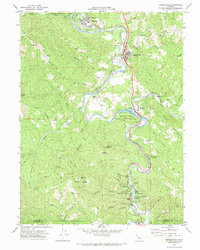
 1949 Garberville1963 Print · USGSThe South Fork Eel River canyon in the late 1940s was the heart of Humboldt's redwood country. Researchers can trace the mid-century development of Garberville, find the Oakdale Sch, and locate old settlements like Briceland and Ettersburg before modern growth.3 unique versions available
 - 1951 Map of Garberville
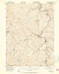 1951 Garberville1951 Print · USGSSouthern Humboldt County is defined by the winding course of the river and the redwoods in the early fifties. Genealogists and historians can trace the development of river towns like Garberville or locate rural schools such as Oakdale Sch and South Fork Union H S.2 unique versions available
 - 1958 Map of Redding
 1958 Redding1958 Print · USGSNorthern California's valley and mountain landscapes are captured in the late fifties, showing the region as new reservoirs reshaped the river systems. Genealogists and historians can trace rail-side towns like Cottonwood, the military presence at Red Bluff Air Force Station, and mountain outposts like Weaverville.5 unique versions available
 - 1970 Map of Garberville, 1974 Print
 1970 Garberville1974 Print · USGSCoastal canyon life along the South Fork Eel River is captured here during the 1970s. Local researchers can trace family landmarks and rural holdings from Boyer Ranch and Pauli Ranch to the early resort grounds of Benbow.
 - 1979 Map of Garberville, 1996 Print
 1979 Garberville1996 Print · USGSThe redwood forests and river canyons of Humboldt and Trinity counties are shown here in the late seventies. Genealogists and historians can trace rail-side life along the Northwestern Pacific RR or locate small settlements like Fort Seward, Alderpoint, and Zenia.
End of results
Showing maps 1-6 of 6
Top cities near Beall Place
Frequently asked questions
- What are the different types of historical maps available for Beall Place?
- What is the oldest map of Beall Place?
- Where can I purchase historical maps of Beall Place for my home or office?
- Where can I download high-res historical maps of Beall Place?
- Are there historical topographic maps available for Beall Place?
- Is there historical aerial imagery available for Beall Place?
- Where are historical maps of Beall Place sourced from?