1940s Maps of Hunter Place, California
Explore 2 historic maps of Hunter Place from the 1940s. These maps offer a rare glimpse into what life looked like during the 1940s — showing old roads, neighborhoods, homes, and landmarks that have changed or disappeared over time.
Whether you're researching your family's past, planning a metal detecting trip, or studying how Hunter Place's landscape evolved across the 1940s, these high-resolution maps are a powerful tool for exploring the history of this region.
- Focus on a specific era: All maps on this page are from the 1940s, giving you a focused view of this time period.
- See what’s changed: Compare century-old streets, trails, and buildings to today's modern landscape using overlays and satellite layers.
- Research with precision: Use these maps for genealogy, historical research, land use analysis, or educational projects.
- View, download, or print: Maps are fully viewable online in high resolution, and can be downloaded or printed for your own records.
Start exploring Hunter Place's history through authentic maps from the 1940s. This is your window into the past.
Hunter Place, CA maps
(2)- 1949 Map of Eureka
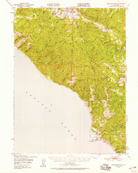
 1949 Eureka1949 Print · USGSCoastal Northern California in the late 1940s shows a landscape of timber towns and maritime outposts. You can trace the Northwestern Pacific rail line through Eureka or locate family landmarks like the Tyson Chrome Mine and Crescent City Lighthouse.2 unique versions available
 - 1949 Map of Point Delgada, 1958 Print
 1949 Point Delgada1958 Print · USGSCoastal Humboldt County is seen here just after the war, showing the dramatic interface of the King Range and the sea. Researchers can trace the early layout of Shelter Cove and its Airstrip, or locate Oil Wells and the remote settlement of Honeydew.2 unique versions available
End of results
Showing maps 1-2 of 2
Top cities near Hunter Place
Frequently asked questions
- What are the different types of historical maps available for Hunter Place?
- What is the oldest map of Hunter Place?
- Where can I purchase historical maps of Hunter Place for my home or office?
- Where can I download high-res historical maps of Hunter Place?
- Are there historical topographic maps available for Hunter Place?
- Is there historical aerial imagery available for Hunter Place?
- Where are historical maps of Hunter Place sourced from?