1970s Maps of Rio Dell, California
Explore 2 historic maps of Rio Dell from the 1970s. These maps offer a rare glimpse into what life looked like during the 1970s — showing old roads, neighborhoods, homes, and landmarks that have changed or disappeared over time.
Whether you're researching your family's past, planning a metal detecting trip, or studying how Rio Dell's landscape evolved across the 1970s, these high-resolution maps are a powerful tool for exploring the history of this region.
- Focus on a specific era: All maps on this page are from the 1970s, giving you a focused view of this time period.
- See what’s changed: Compare century-old streets, trails, and buildings to today's modern landscape using overlays and satellite layers.
- Research with precision: Use these maps for genealogy, historical research, land use analysis, or educational projects.
- View, download, or print: Maps are fully viewable online in high resolution, and can be downloaded or printed for your own records.
Start exploring Rio Dell's history through authentic maps from the 1970s. This is your window into the past.
Rio Dell, CA maps
(2)- 1970 Map of Scotia, 1974 Print
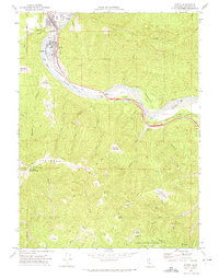 1970 Scotia1974 Print · USGSHumboldt County’s river-bound lumber towns are shown in the early 1970s as they transition from industrial hubs into parklands. You can trace the Northwestern Pacific railroad corridor and locate named clearings like Barkdull Prairie and Harrow Springs.
 - 1979 Map of Hydesville
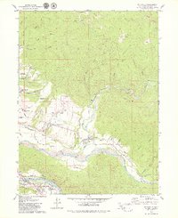 1979 Hydesville1979 Print · USGSHumboldt County’s timber and river communities are shown in the late seventies as industry and settlement expanded along the Eel River. Researchers can trace family sites at Rohnerville Cemetery, locate the Cuddeback Sch, or follow the Northwestern Pacific Railroad through Carlotta.2 unique versions available
End of results
Showing maps 1-2 of 2
Top cities near Rio Dell
- Fortuna historical maps
- Fortuna historical maps
- Ferndale historical maps
- Loleta historical maps
- Scotia historical maps
- Petrolia historical maps
Top neighborhoods of Rio Dell
Frequently asked questions
- What are the different types of historical maps available for Rio Dell?
- What is the oldest map of Rio Dell?
- Where can I purchase historical maps of Rio Dell for my home or office?
- Where can I download high-res historical maps of Rio Dell?
- Are there historical topographic maps available for Rio Dell?
- Is there historical aerial imagery available for Rio Dell?
- Where are historical maps of Rio Dell sourced from?