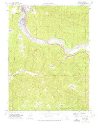
1970 Map of Scotia
USGS Topo · Published 1974About this map
Scotia and Rio Dell occupy the banks of the Eel River in this 1970 survey, reflecting the industrial character of these lumber-related settlements. Industrial infrastructure like Burners, a Substation, and numerous Water Tanks are prominent in the Scotia area, while the Northwestern Pacific railroad tracks hug the riverbank to transport timber and goods. The landscape transitions from these populated hubs into the high, ridge-filled terrain of Monument Ridge, rising toward the summit of Mt Pierce.
Find a feature on this map
59 named features on this map. Tap any name to fly to it.
Don’t see what you’re looking for? This feature index may not catch every label — zoom into the map to look around manually.
Map Details
Editions of this 1970 Scotia Map
This is the sole edition of this map. No revisions or reprints were ever made.
Other maps of this area

1919 · Glynn
USGS Topo · 1:62,500

1921 · Dyerville
USGS Topo · 1:62,500

1922 · Kneeland
USGS Topo · 1:62,500

1944 · Fortuna
USGS Topo · 1:62,500

1949 · Eureka
USGS Topo · 1:250,000

1949 · Weott
USGS Topo · 1:62,500

1950 · Iaqua Buttes
USGS Topo · 1:62,500

1950 · Scotia
USGS Topo · 1:62,500

1951 · Scotia
USGS Topo · 1:62,500

1951 · Weott
USGS Topo · 1:62,500