
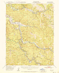
1951 Map of Weott
USGS Topo · Published 1951About this map
Humboldt Redwoods State Park dominates this mid-century survey, showcasing a landscape defined by towering groves and the winding courses of the Eel River and its South Fork. The map documents the early infrastructure of the redwood coast, where the Redwood Highway and the Avenue of the Giants thread through named preserves like the Garden Club of America Grove and Founders Grove, the latter noted for its Tallest Tree.
Find a feature on this map
130 named features on this map. Tap any name to fly to it.
Don’t see what you’re looking for? This feature index may not catch every label — zoom into the map to look around manually.
Map Details
Editions of this 1951 Weott Map
2 editions found
Other maps of this area

1914 · Pilot Creek
USGS Topo · 1:62,500

1915 · Big Bar and Vicinity
USGS Topo · 1:250,000

1919 · Glynn
USGS Topo · 1:62,500

1920 · Pt. Delagda
USGS Topo · 1:62,500

1920 · Harris
USGS Topo · 1:62,500

1921 · Dyerville
USGS Topo · 1:62,500

1921 · Briceland
USGS Topo · 1:62,500

1922 · Kneeland
USGS Topo · 1:62,500

1944 · Fortuna
USGS Topo · 1:62,500

1949 · Eureka
USGS Topo · 1:250,000