1940s Maps of Calexico, California
Explore 5 historic maps of Calexico from the 1940s. These maps offer a rare glimpse into what life looked like during the 1940s — showing old roads, neighborhoods, homes, and landmarks that have changed or disappeared over time.
Whether you're researching your family's past, planning a metal detecting trip, or studying how Calexico's landscape evolved across the 1940s, these high-resolution maps are a powerful tool for exploring the history of this region.
- Focus on a specific era: All maps on this page are from the 1940s, giving you a focused view of this time period.
- See what’s changed: Compare century-old streets, trails, and buildings to today's modern landscape using overlays and satellite layers.
- Research with precision: Use these maps for genealogy, historical research, land use analysis, or educational projects.
- View, download, or print: Maps are fully viewable online in high resolution, and can be downloaded or printed for your own records.
Start exploring Calexico's history through authentic maps from the 1940s. This is your window into the past.
Calexico, CA maps
(5)- 1940 Map of Heber, 1956 Print
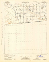
 1940 Heber1956 Print · USGSThe Imperial Valley borderlands are captured here in the early 1940s, showing the complex web of irrigation and desert life. Trace the development of Heber and Calexico alongside the massive All American Canal and the family-linked Mt Signal Union Sch.
 - 1940 Map of Calexico, 1957 Print
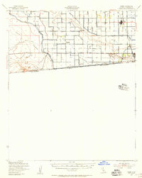
 1940 Calexico1957 Print · USGSThe Imperial Valley borderlands come into focus at the dawn of the 1940s, showing the early impact of the All American Canal. Trace the development of Calexico and rural landmarks like Bonds Corner, Jasper Sch, and the Alamo River.
 - 1942 Map of El Centro
 1942 El Centro1942 Print · USGSThe Imperial Valley and the California-Mexico border are captured during the peak of World War II-era desert development. Genealogists and historians can trace defunct school districts like Meloland Sch and Sandia, or follow the path of the Inter-California Railroad across the international line.2 unique versions available
 - 1943 Map of Heber, 1945 Print
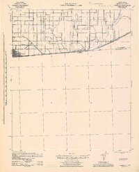
 1943 Heber1945 Print · USGSThe Imperial Valley borderlands thrived during the 1940s as a highly engineered agricultural landscape along the Mexico boundary. Genealogists can trace rural life through landmarks like Mt Signal Union Sch and the extensive network of irrigation ditches including the Dahlia Canal and All American Canal.
 - 1943 Map of Calexico, 1945 Print
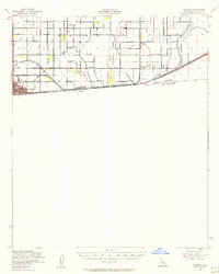
 1943 Calexico1945 Print · USGSThe Imperial Valley's borderlands and irrigation networks are shown in detail during the 1940s. Genealogists and researchers can trace the rural landscape around Calexico and Bonds Corner, identifying local landmarks like Jasper Sch and the massive All American Canal.
End of results
Showing maps 1-5 of 5
Top cities near Calexico
Frequently asked questions
- What are the different types of historical maps available for Calexico?
- What is the oldest map of Calexico?
- Where can I purchase historical maps of Calexico for my home or office?
- Where can I download high-res historical maps of Calexico?
- Are there historical topographic maps available for Calexico?
- Is there historical aerial imagery available for Calexico?
- Where are historical maps of Calexico sourced from?