1940s Maps of Calipatria, California
Explore 3 historic maps of Calipatria from the 1940s. These maps offer a rare glimpse into what life looked like during the 1940s — showing old roads, neighborhoods, homes, and landmarks that have changed or disappeared over time.
Whether you're researching your family's past, planning a metal detecting trip, or studying how Calipatria's landscape evolved across the 1940s, these high-resolution maps are a powerful tool for exploring the history of this region.
- Focus on a specific era: All maps on this page are from the 1940s, giving you a focused view of this time period.
- See what’s changed: Compare century-old streets, trails, and buildings to today's modern landscape using overlays and satellite layers.
- Research with precision: Use these maps for genealogy, historical research, land use analysis, or educational projects.
- View, download, or print: Maps are fully viewable online in high resolution, and can be downloaded or printed for your own records.
Start exploring Calipatria's history through authentic maps from the 1940s. This is your window into the past.
Calipatria, CA maps
(3)- 1940 Map of Iris, 1956 Print
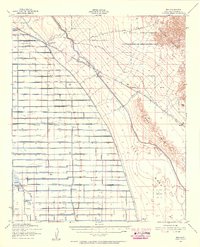 1940 Iris1956 Print · USGSImperial County at the start of the 1940s showcases a desert undergoing industrial transformation through a vast network of irrigation canals. Genealogists and historians can trace rail sidings like Flowing Well Siding and rural landmarks such as Mulberry Sch or the settlement of Wiest.4 unique versions available
 - 1944 Map of Calipatria, 1945 Print
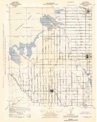 1944 Calipatria1945 Print · USGSThe Imperial Valley's desert reclamation and wartime agriculture are in full focus on this mid-1940s survey. Genealogists and local historians can trace the growth of Calipatria and Niland or locate rural landmarks like the Trifolium School and Hovley Siding.4 unique versions available
 - 1945 Map of Iris
 1945 Iris1945 Print · USGSImperial County at the close of the war shows a landscape divided between the harsh desert and a burgeoning irrigation empire. Genealogists and historians can trace the early desert outposts of Iris and Tortuga alongside local landmarks like Mulberry Sch.
End of results
Showing maps 1-3 of 3
Top cities near Calipatria
- Brawley historical maps
- Westmorland historical maps
- Slab City historical maps
- Poe Colonia historical maps
Frequently asked questions
- What are the different types of historical maps available for Calipatria?
- What is the oldest map of Calipatria?
- Where can I purchase historical maps of Calipatria for my home or office?
- Where can I download high-res historical maps of Calipatria?
- Are there historical topographic maps available for Calipatria?
- Is there historical aerial imagery available for Calipatria?
- Where are historical maps of Calipatria sourced from?