1950s Maps of Aspendell, California
Explore 4 historic maps of Aspendell from the 1950s. These maps offer a rare glimpse into what life looked like during the 1950s — showing old roads, neighborhoods, homes, and landmarks that have changed or disappeared over time.
Whether you're researching your family's past, planning a metal detecting trip, or studying how Aspendell's landscape evolved across the 1950s, these high-resolution maps are a powerful tool for exploring the history of this region.
- Focus on a specific era: All maps on this page are from the 1950s, giving you a focused view of this time period.
- See what’s changed: Compare century-old streets, trails, and buildings to today's modern landscape using overlays and satellite layers.
- Research with precision: Use these maps for genealogy, historical research, land use analysis, or educational projects.
- View, download, or print: Maps are fully viewable online in high resolution, and can be downloaded or printed for your own records.
Start exploring Aspendell's history through authentic maps from the 1950s. This is your window into the past.
Aspendell, CA maps
(4)- 1951 Map of Mt. Goddard
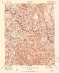 1951 Mt. Goddard1951 Print · USGSHigh Sierra wilderness and the crest of the Sierra Nevada are captured here in the early fifties, documenting a vast landscape of granite peaks and glacial lakes. Researchers can trace historic mineral sites like the Cardinal Mine and Sally Peterson Mine or locate high-country crossings at Muir Pass.2 unique versions available
 - 1952 Map of Mt. Goddard
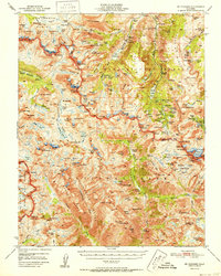 1952 Mt. Goddard1952 Print · USGSThe High Sierra backcountry is captured here in the early fifties, documenting the remote intersection of Fresno and Inyo counties. Researchers can trace the era's mining and recreation footprint at sites like Schober Mine, Parchers Camp, and the Cardinal Mine.2 unique versions available
 - 1957 Map of Mt. Goddard, 1964 Print
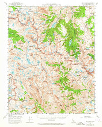 1957 Mt. Goddard1964 Print · USGSThe High Sierra divide at the border of Inyo and Fresno counties is shown here in the mid-1950s during a period of transition for the high country. You can trace the historic route of the John Muir Trail past McClure Meadow or locate early mining sites like the Salty Peterson Mine and Cardinal Mine.3 unique versions available
 - 1957 Map of Mariposa, 1966 Print
 1957 Mariposa1966 Print · USGSThe High Sierra and Owens Valley appear in the mid-fifties, showing the intersection of conservation, hydroelectric power, and mountain industry. Genealogists and researchers can trace local landmarks like Yosemite Cemetery, the remote Kinsley Station, and the Pine Creek Mine.4 unique versions available
End of results
Showing maps 1-4 of 4
Top cities near Aspendell
- Bishop historical maps
- Dixon Lane–Meadow Creek historical maps
- West Bishop historical maps
- Wilkerson historical maps
- Round Valley historical maps
- Mesa historical maps
Frequently asked questions
- What are the different types of historical maps available for Aspendell?
- What is the oldest map of Aspendell?
- Where can I purchase historical maps of Aspendell for my home or office?
- Where can I download high-res historical maps of Aspendell?
- Are there historical topographic maps available for Aspendell?
- Is there historical aerial imagery available for Aspendell?
- Where are historical maps of Aspendell sourced from?