1980s Maps of Olancha, California
Explore 5 historic maps of Olancha from the 1980s. These maps offer a rare glimpse into what life looked like during the 1980s — showing old roads, neighborhoods, homes, and landmarks that have changed or disappeared over time.
Whether you're researching your family's past, planning a metal detecting trip, or studying how Olancha's landscape evolved across the 1980s, these high-resolution maps are a powerful tool for exploring the history of this region.
- Focus on a specific era: All maps on this page are from the 1980s, giving you a focused view of this time period.
- See what’s changed: Compare century-old streets, trails, and buildings to today's modern landscape using overlays and satellite layers.
- Research with precision: Use these maps for genealogy, historical research, land use analysis, or educational projects.
- View, download, or print: Maps are fully viewable online in high resolution, and can be downloaded or printed for your own records.
Start exploring Olancha's history through authentic maps from the 1980s. This is your window into the past.
Olancha, CA maps
(5)- 1982 Map of Haiwee Reservoirs, 1983 Print
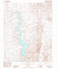 1982 Haiwee Reservoirs1983 Print · USGSThe Owens Valley water system is showcased in the early eighties, highlighting the essential infrastructure of the Los Angeles Aqueduct. Trace the engineering of the North Haiwee Dam and locate local mining sites like the Jack Henry Mine and McCloud Mine.
 - 1985 Map of Darwin Hills
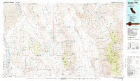 1985 Darwin Hills1985 Print · USGSInyo County's rugged mining districts and the eastern Sierra approach are captured here in the mid-1980s. Historians and researchers can trace the old Southern Pacific rail line, locate the Lookout City (Site), and find remote desert works like the Modoc Mine.2 unique versions available
 - 1987 Map of Haiwee Pass
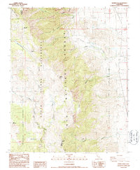 1987 Haiwee Pass1987 Print · USGSThe high Sierra Nevada backcountry meets the Owens Valley in the late twentieth century, showing the transition from wilderness to infrastructure. Trace the early path of the Pacific Crest National Scenic Trail past Bear Trap Meadow and the remote Dutch John Flat.2 unique versions available
 - 1987 Map of Vermillion Canyon
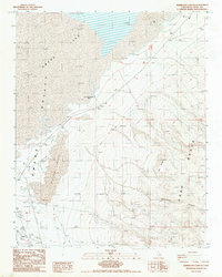 1987 Vermillion Canyon1987 Print · USGSOwens Valley in the late 1980s reveals a high-desert landscape shaped by mineral prospecting and water infrastructure. Researchers can trace the small settlement of Grant, locate the Dirty Socks Spring (Hot), and explore industrial sites like the Open Pit Mine.
 - 1988 Map of Olancha
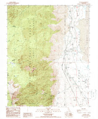 1988 Olancha1988 Print · USGSThe Owens Valley shoreline and the high Sierra peaks meet in this late-eighties survey of Inyo County. Trace the industrial footprint of the Southern Pacific Railroad and Los Angeles Aqueduct near the settlements of Cartago and Olancha.2 unique versions available
End of results
Showing maps 1-5 of 5
Top neighborhoods of Olancha
Frequently asked questions
- What are the different types of historical maps available for Olancha?
- What is the oldest map of Olancha?
- Where can I purchase historical maps of Olancha for my home or office?
- Where can I download high-res historical maps of Olancha?
- Are there historical topographic maps available for Olancha?
- Is there historical aerial imagery available for Olancha?
- Where are historical maps of Olancha sourced from?