1980s Maps of Stewart Valley, California
Explore 2 historic maps of Stewart Valley from the 1980s. These maps offer a rare glimpse into what life looked like during the 1980s — showing old roads, neighborhoods, homes, and landmarks that have changed or disappeared over time.
Whether you're researching your family's past, planning a metal detecting trip, or studying how Stewart Valley's landscape evolved across the 1980s, these high-resolution maps are a powerful tool for exploring the history of this region.
- Focus on a specific era: All maps on this page are from the 1980s, giving you a focused view of this time period.
- See what’s changed: Compare century-old streets, trails, and buildings to today's modern landscape using overlays and satellite layers.
- Research with precision: Use these maps for genealogy, historical research, land use analysis, or educational projects.
- View, download, or print: Maps are fully viewable online in high resolution, and can be downloaded or printed for your own records.
Start exploring Stewart Valley's history through authentic maps from the 1980s. This is your window into the past.
Stewart Valley, CA maps
(2)- 1984 Map of Stewart Valley
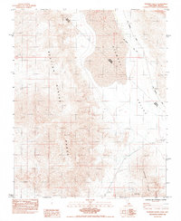 1984 Stewart Valley1984 Print · USGSThe California-Nevada borderlands are mapped here in the early eighties as a rugged corridor of mining and early surveying. Trace historical boundaries along the Von Schmidt Line (1873) or locate desert work sites like the Shaw Mine and Gravel Pit.
 - 1986 Map of Death Valley Junction
 1986 Death Valley Junction1986 Print · USGSThe California-Nevada borderlands appear here in the mid-eighties, centered on the dramatic terrain of the Death Valley National Monument. Researchers can trace the path of the Tonopah and Tidewater Railroad (Abandoned) and locate remote outposts like Ryan and Bennetts Well.2 unique versions available
End of results
Showing maps 1-2 of 2
Top cities near Stewart Valley
Frequently asked questions
- What are the different types of historical maps available for Stewart Valley?
- What is the oldest map of Stewart Valley?
- Where can I purchase historical maps of Stewart Valley for my home or office?
- Where can I download high-res historical maps of Stewart Valley?
- Are there historical topographic maps available for Stewart Valley?
- Is there historical aerial imagery available for Stewart Valley?
- Where are historical maps of Stewart Valley sourced from?