1960s Maps of Annette, California
Explore 2 historic maps of Annette from the 1960s. These maps offer a rare glimpse into what life looked like during the 1960s — showing old roads, neighborhoods, homes, and landmarks that have changed or disappeared over time.
Whether you're researching your family's past, planning a metal detecting trip, or studying how Annette's landscape evolved across the 1960s, these high-resolution maps are a powerful tool for exploring the history of this region.
- Focus on a specific era: All maps on this page are from the 1960s, giving you a focused view of this time period.
- See what’s changed: Compare century-old streets, trails, and buildings to today's modern landscape using overlays and satellite layers.
- Research with precision: Use these maps for genealogy, historical research, land use analysis, or educational projects.
- View, download, or print: Maps are fully viewable online in high resolution, and can be downloaded or printed for your own records.
Start exploring Annette's history through authentic maps from the 1960s. This is your window into the past.
Annette, CA maps
(2)- 1961 Map of Orchard Peak, 1962 Print
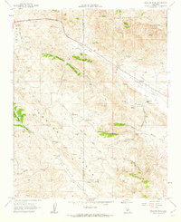 1961 Orchard Peak1962 Print · USGSThe high Temblor Range and Polonio Pass in the early sixties reveal a landscape of remote ranching and emerging energy infrastructure. Researchers can locate the settlement of Annette, trace the Antelope Grade, and find isolated water sources like Twisselmann Lake.2 unique versions available
 - 1961 Map of Orchard Peak, 1962 Print
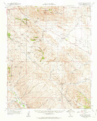 1961 Orchard Peak1962 Print · USGSThe Temblor Range and the Kern-San Luis Obispo border area come into focus in the early sixties as the regional oil and water infrastructure expands. Researchers can trace the era's industrial footprint through Oil Wells at Devils Den and the Antelope Pumping Sta.
End of results
Showing maps 1-2 of 2
Top cities near Annette
Frequently asked questions
- What are the different types of historical maps available for Annette?
- What is the oldest map of Annette?
- Where can I purchase historical maps of Annette for my home or office?
- Where can I download high-res historical maps of Annette?
- Are there historical topographic maps available for Annette?
- Is there historical aerial imagery available for Annette?
- Where are historical maps of Annette sourced from?