1930s Maps of Corn Camp, California
Explore 2 historic maps of Corn Camp from the 1930s. These maps offer a rare glimpse into what life looked like during the 1930s — showing old roads, neighborhoods, homes, and landmarks that have changed or disappeared over time.
Whether you're researching your family's past, planning a metal detecting trip, or studying how Corn Camp's landscape evolved across the 1930s, these high-resolution maps are a powerful tool for exploring the history of this region.
- Focus on a specific era: All maps on this page are from the 1930s, giving you a focused view of this time period.
- See what’s changed: Compare century-old streets, trails, and buildings to today's modern landscape using overlays and satellite layers.
- Research with precision: Use these maps for genealogy, historical research, land use analysis, or educational projects.
- View, download, or print: Maps are fully viewable online in high resolution, and can be downloaded or printed for your own records.
Start exploring Corn Camp's history through authentic maps from the 1930s. This is your window into the past.
Corn Camp, CA maps
(2)- 1931 Map of Lokern
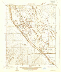 1931 Lokern1931 Print · USGSKern County's agricultural and industrial plumbing is laid bare in the early 1930s, showing a landscape defined by massive irrigation and rail projects. You can trace the path of the Southern Pacific through the crossroads at Lokern or locate multiple Indian Burial Mounds along the Buena Vista Slough.
 - 1934 Map of Lokern
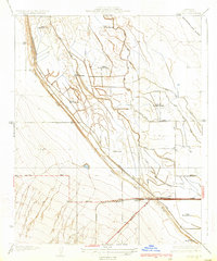 1934 Lokern1934 Print · USGSThe San Joaquin Valley landscape near Lokern was a maze of irrigation and ancient sites in the 1930s. Genealogists and historians can trace the intersection of the Southern Pacific railroad and the Buena Vista Slough near several Indian Burial Mounds.2 unique versions available
End of results
Showing maps 1-2 of 2
Top cities near Corn Camp
Frequently asked questions
- What are the different types of historical maps available for Corn Camp?
- What is the oldest map of Corn Camp?
- Where can I purchase historical maps of Corn Camp for my home or office?
- Where can I download high-res historical maps of Corn Camp?
- Are there historical topographic maps available for Corn Camp?
- Is there historical aerial imagery available for Corn Camp?
- Where are historical maps of Corn Camp sourced from?