1920s Maps of Delano, California
Explore 3 historic maps of Delano from the 1920s. These maps offer a rare glimpse into what life looked like during the 1920s — showing old roads, neighborhoods, homes, and landmarks that have changed or disappeared over time.
Whether you're researching your family's past, planning a metal detecting trip, or studying how Delano's landscape evolved across the 1920s, these high-resolution maps are a powerful tool for exploring the history of this region.
- Focus on a specific era: All maps on this page are from the 1920s, giving you a focused view of this time period.
- See what’s changed: Compare century-old streets, trails, and buildings to today's modern landscape using overlays and satellite layers.
- Research with precision: Use these maps for genealogy, historical research, land use analysis, or educational projects.
- View, download, or print: Maps are fully viewable online in high resolution, and can be downloaded or printed for your own records.
Start exploring Delano's history through authentic maps from the 1920s. This is your window into the past.
Delano, CA maps
(3)- 1927 Map of McFarland
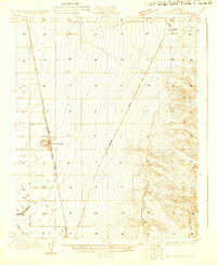 1927 McFarland1927 Print · USGSCentral Valley agriculture and transportation converge in the late twenties near the Kern County line. Genealogists and historians can trace the early townsite of McFarland and the settlement of Jasmine along the Southern Pacific rail lines.
 - 1929 Map of Delano
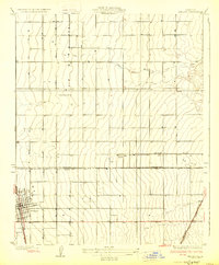 1929 Delano1929 Print · USGSThe San Joaquin Valley's agricultural heartland is captured here in the late twenties, showing the growth of the Central Valley rail corridor. Genealogists and local historians can trace early town plats in Delano, rural school locations like Columbine Sch, and the original route of the Orange Belt Highway.2 unique versions available
 - 1929 Map of Stone
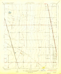 1929 Stone1929 Print · USGSThe southern San Joaquin Valley during the late 1920s shows a landscape of expanding rail and agricultural lines. Genealogists and local historians can trace the early layout of Stone, Delano, and Kernell along the Southern Pacific tracks.3 unique versions available
End of results
Showing maps 1-3 of 3
Top cities near Delano
- Wasco historical maps
- Shafter historical maps
- McFarland historical maps
- Earlimart historical maps
- Terra Bella historical maps
- Pixley historical maps
See more
Top neighborhoods of Delano
Frequently asked questions
- What are the different types of historical maps available for Delano?
- What is the oldest map of Delano?
- Where can I purchase historical maps of Delano for my home or office?
- Where can I download high-res historical maps of Delano?
- Are there historical topographic maps available for Delano?
- Is there historical aerial imagery available for Delano?
- Where are historical maps of Delano sourced from?