1950s Maps of Delano, California
Explore 6 historic maps of Delano from the 1950s. These maps offer a rare glimpse into what life looked like during the 1950s — showing old roads, neighborhoods, homes, and landmarks that have changed or disappeared over time.
Whether you're researching your family's past, planning a metal detecting trip, or studying how Delano's landscape evolved across the 1950s, these high-resolution maps are a powerful tool for exploring the history of this region.
- Focus on a specific era: All maps on this page are from the 1950s, giving you a focused view of this time period.
- See what’s changed: Compare century-old streets, trails, and buildings to today's modern landscape using overlays and satellite layers.
- Research with precision: Use these maps for genealogy, historical research, land use analysis, or educational projects.
- View, download, or print: Maps are fully viewable online in high resolution, and can be downloaded or printed for your own records.
Start exploring Delano's history through authentic maps from the 1950s. This is your window into the past.
Delano, CA maps
(6)- 1953 Map of Pond, 1955 Print
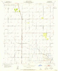 1953 Pond1955 Print · USGSIn the fertile San Joaquin Valley during the mid-fifties, this area shows the transition from open range to intensive irrigation. Genealogists and local researchers can trace the rail corridor of the Atchison Topeka and Santa Fe through Pond and find the rural Pondham Sch.4 unique versions available
 - 1953 Map of Delano East, 1955 Print
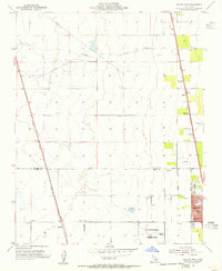
 1953 Delano East1955 Print · USGSThe eastern edge of Delano is shown here at the peak of mid-century agricultural expansion, split by the Tulare and Kern County line. Genealogists and researchers can locate family-named roads and landmarks like Columbine Sch, Sierra Vista Ranch, and the Delano Airport.3 unique versions available
 - 1954 Map of Mc Farland, 1955 Print
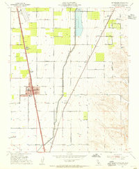 1954 Mc Farland1955 Print · USGSKern County agriculture and rail industry are in sharp focus during the mid-fifties as irrigation canals transformed the landscape. Researchers can trace family-named roads like Hart Road, locate the Cem near Calico, and see the footprint of McFarland along the Southern Pacific line.3 unique versions available
 - 1954 Map of Delano West, 1955 Print
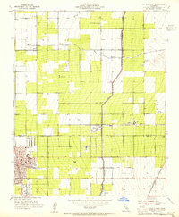
 1954 Delano West1955 Print · USGSThe San Joaquin Valley’s industrial-agricultural fringe is captured in the mid-fifties, showing the vital intersection of two major railroads. Researchers can trace the local shipping economy through numerous sidings like Caratan and locate institutions such as Fremont Sch and the Delano-McFarland District Cem.5 unique versions available
 - 1955 Map of Bakersfield
 1955 Bakersfield1955 Print · USGSThe southern San Joaquin Valley in the mid-fifties shows an era of massive oil production and industrial irrigation. Trace family roots in Allensworth, the oil fields of Oildale, or the shorelines of Tulare Lake and Buena Vista Lake.
 - 1956 Map of Bakersfield
 1956 Bakersfield1956 Print · USGSThe southern San Joaquin Valley and High Sierra come alive in the mid-fifties, showing the region's complex agricultural and rail networks. Genealogists and historians can trace family roots in towns like Bakersfield, Taft, and Delano, or locate early infrastructure along the Sunset Railway.
End of results
Showing maps 1-6 of 6
Top cities near Delano
- Wasco historical maps
- Shafter historical maps
- McFarland historical maps
- Earlimart historical maps
- Terra Bella historical maps
- Pixley historical maps
See more
Top neighborhoods of Delano
Frequently asked questions
- What are the different types of historical maps available for Delano?
- What is the oldest map of Delano?
- Where can I purchase historical maps of Delano for my home or office?
- Where can I download high-res historical maps of Delano?
- Are there historical topographic maps available for Delano?
- Is there historical aerial imagery available for Delano?
- Where are historical maps of Delano sourced from?