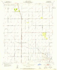
1953 Map of Pond
USGS Topo · Published 1955About this map
The Atchison Topeka and Santa Fe railroad corridor anchors this agricultural landscape in the San Joaquin Valley, connecting the small settlements of Pond and Elmo. The grid-like survey pattern is defined by family-named thoroughfares such as Schuster Road, Mettler Road, and Hiett Ave, reflecting the systematic development of the Kern County countryside during the mid-1950s. While irrigation infrastructure like the Canal and Levee system in the south suggest intensive land management, a large US Govt Reservation and several private Landing Strips point to the area's diverse usage. Education for the surrounding farming families was centralized at the Pondham Sch, located just east of the main rail line. The natural meandering of Poso Creek contrasts sharply with the rigid township sections and the industrial Seepage Ponds near the Calloway Ave crossing.
Find a feature on this map
34 named features on this map. Tap any name to fly to it.
Don’t see what you’re looking for? This feature index may not catch every label — zoom into the map to look around manually.
Map Details
Editions of this 1953 Pond Map
4 editions found
Other maps of this area

1927 · McFarland
USGS Topo · 1:31,680

1929 · Delano
USGS Topo · 1:31,680

1929 · Stone
USGS Topo · 1:31,680

1929 · Allensworth
USGS Topo · 1:31,680

1930 · McFarland
USGS Topo · 1:31,680

1930 · Leonards
USGS Topo · 1:31,680

1930 · Hamlin School
USGS Topo · 1:31,680

1930 · Wasco
USGS Topo · 1:31,680

1930 · Pond
USGS Topo · 1:31,680

1930 · Famoso
USGS Topo · 1:31,680