1970s Maps of Lake Isabella, California
Explore 2 historic maps of Lake Isabella from the 1970s. These maps offer a rare glimpse into what life looked like during the 1970s — showing old roads, neighborhoods, homes, and landmarks that have changed or disappeared over time.
Whether you're researching your family's past, planning a metal detecting trip, or studying how Lake Isabella's landscape evolved across the 1970s, these high-resolution maps are a powerful tool for exploring the history of this region.
- Focus on a specific era: All maps on this page are from the 1970s, giving you a focused view of this time period.
- See what’s changed: Compare century-old streets, trails, and buildings to today's modern landscape using overlays and satellite layers.
- Research with precision: Use these maps for genealogy, historical research, land use analysis, or educational projects.
- View, download, or print: Maps are fully viewable online in high resolution, and can be downloaded or printed for your own records.
Start exploring Lake Isabella's history through authentic maps from the 1970s. This is your window into the past.
Lake Isabella, CA maps
(2)- 1972 Map of Lake Isabella South, 1975 Print
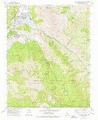 1972 Lake Isabella South1975 Print · USGSIn the early seventies, the southern Sierra foothills near Lake Isabella were a landscape of deep canyons and active mining claims. Researchers can trace the footprints of old workings like the Tom Moore Mine and Glen Olive Mine, or locate family sites at Harrington Ranch and Liebel Ranch.3 unique versions available
 - 1978 Map of Isabella Lake, 1994 Print
 1978 Isabella Lake1994 Print · USGSKern County's high country and the central reservoir system are detailed here during the late seventies. Researchers can trace historical sites like Havilah and Long Tom Mine, or explore the development around Isabella Lake and Wofford Heights.2 unique versions available
End of results
Showing maps 1-2 of 2
Top cities near Lake Isabella
Frequently asked questions
- What are the different types of historical maps available for Lake Isabella?
- What is the oldest map of Lake Isabella?
- Where can I purchase historical maps of Lake Isabella for my home or office?
- Where can I download high-res historical maps of Lake Isabella?
- Are there historical topographic maps available for Lake Isabella?
- Is there historical aerial imagery available for Lake Isabella?
- Where are historical maps of Lake Isabella sourced from?