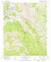
1972 Map of Lake Isabella South
USGS Topo · Published 1975About this map
Lake Isabella and the settlement of Bodfish sit at the northern edge of this high-elevation terrain, where the Kern River flows into the Hot Spring Valley. The 1970s landscape is defined by the proximity of the Sequoia National Forest and a complex network of mining sites scattered throughout the canyons and ridges. Notable operations including the Tom Moore Mine, Glen Olive Mine, and Seventyfour Mine dot the slopes of Laura Peak and Bodfish Peak, pointing to a history of hard-rock extraction in the Erskine Creek and Bodfish Creek drainages. Evidence of early industry and habitation appears in the form of multiple ruins, including the Faust Mill and the Borel Flume, while Severn Hot Springs and Squirrel Mountain Valley suggest the area's development for both resource extraction and recreation.
Find a feature on this map
49 named features on this map. Tap any name to fly to it.
Don’t see what you’re looking for? This feature index may not catch every label — zoom into the map to look around manually.
Map Details
Editions of this 1972 Lake Isabella South Map
3 editions found
Other maps of this area

1906 · Kernville
USGS Topo · 1:125,000

1908 · Kernville
USGS Topo · 1:125,000

1914 · Caliente
USGS Topo · 1:125,000

1915 · Mojave
USGS Topo · 1:125,000

1920 · Delonagha
USGS Topo · 1:62,500

1926 · Glennville
USGS Topo · 1:62,500

1936 · Tobias Peak
USGS Topo · 1:125,000

1943 · Emerald Mtn
USGS Topo · 1:62,500

1943 · Breckenridge Mountain
USGS Topo · 1:62,500

1943 · Tobias Peak
USGS Topo · 1:125,000