1930s Maps of McFarland, California
Explore 2 historic maps of McFarland from the 1930s. These maps offer a rare glimpse into what life looked like during the 1930s — showing old roads, neighborhoods, homes, and landmarks that have changed or disappeared over time.
Whether you're researching your family's past, planning a metal detecting trip, or studying how McFarland's landscape evolved across the 1930s, these high-resolution maps are a powerful tool for exploring the history of this region.
- Focus on a specific era: All maps on this page are from the 1930s, giving you a focused view of this time period.
- See what’s changed: Compare century-old streets, trails, and buildings to today's modern landscape using overlays and satellite layers.
- Research with precision: Use these maps for genealogy, historical research, land use analysis, or educational projects.
- View, download, or print: Maps are fully viewable online in high resolution, and can be downloaded or printed for your own records.
Start exploring McFarland's history through authentic maps from the 1930s. This is your window into the past.
McFarland, CA maps
(2)- 1930 Map of McFarland
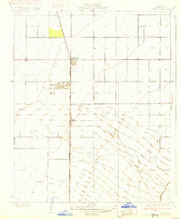
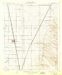 1930 McFarland1930 Print · USGSThe San Joaquin Valley's agricultural heart is captured here in the late twenties as irrigation and rail lines transformed the landscape. Researchers can trace the development of McFarland and Jasmin along the Southern Pacific and the Golden State Highway.2 unique versions available
 - 1930 Map of Pond
 1930 Pond1930 Print · USGSKern County's industrial and rail corridor comes into focus in the late 1920s as the petroleum industry reshaped the valley floor. Researchers can trace the massive Standard Oil Co Storage Tanks at Petro and the small settlements of Pond and Elmo along the Santa Fe line.2 unique versions available
End of results
Showing maps 1-2 of 2
Top cities near McFarland
- Delano historical maps
- Wasco historical maps
- Shafter historical maps
- Earlimart historical maps
- Richgrove historical maps
- Ducor historical maps
See more
Frequently asked questions
- What are the different types of historical maps available for McFarland?
- What is the oldest map of McFarland?
- Where can I purchase historical maps of McFarland for my home or office?
- Where can I download high-res historical maps of McFarland?
- Are there historical topographic maps available for McFarland?
- Is there historical aerial imagery available for McFarland?
- Where are historical maps of McFarland sourced from?