1940s Maps of North Edwards, California
Explore 5 historic maps of North Edwards from the 1940s. These maps offer a rare glimpse into what life looked like during the 1940s — showing old roads, neighborhoods, homes, and landmarks that have changed or disappeared over time.
Whether you're researching your family's past, planning a metal detecting trip, or studying how North Edwards's landscape evolved across the 1940s, these high-resolution maps are a powerful tool for exploring the history of this region.
- Focus on a specific era: All maps on this page are from the 1940s, giving you a focused view of this time period.
- See what’s changed: Compare century-old streets, trails, and buildings to today's modern landscape using overlays and satellite layers.
- Research with precision: Use these maps for genealogy, historical research, land use analysis, or educational projects.
- View, download, or print: Maps are fully viewable online in high resolution, and can be downloaded or printed for your own records.
Start exploring North Edwards's history through authentic maps from the 1940s. This is your window into the past.
North Edwards, CA maps
(5)- 1943 Map of Castle Butte
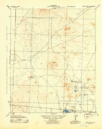 1943 Castle Butte1943 Print · USGSKern County ranching and early desert industry are preserved in this wartime survey of the Mojave. Genealogists and researchers can trace isolated landmarks like G Mendiburu, the Thundering Herd Ranch, and the operations of the Muroc Clay Co.2 unique versions available
 - 1947 Map of Castle Butte
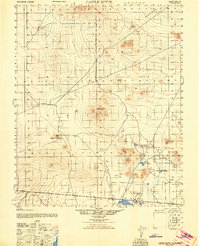 1947 Castle Butte1947 Print · USGSThe high desert of Kern County during the post-war era reveals a landscape of industrial outposts and isolated ranching. Trace early mineral operations at Muroc Clay Co and family landmarks like G Mendiburu or the Thundering Herd Ranch.
 - 1947 Map of Castle Butte SE
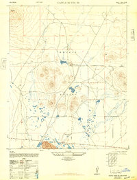 1947 Castle Butte SE1947 Print · USGSPost-war Kern County is captured here during a period of transition for the high desert. Researchers can trace the early layout of North Muroc and find local landmarks like Castle Butte and the Thundering Herd Ranch.3 unique versions available
 - 1947 Map of Trona, 1948 Print
 1947 Trona1948 Print · USGSThe Mojave Desert and Southern Sierra foothills come alive in the late 1940s, showing the industrial nodes of the Argus Range and the burgeoning Camp Irwin. Trace the legacy of desert mining and railroading through Trona, the Ashford Mill, and the historic districts of Randsburg and Garlock.
 - 1948 Map of Trona
 1948 Trona1948 Print · USGSThe Mojave Desert and Death Valley frontier appear here during a mid-century era of military expansion and industrial mining. Trace the remnants of the Old Spanish Trail or locate isolated landmarks like Ashford Mill and the mining hub of Randsburg.
End of results
Showing maps 1-5 of 5
Top cities near North Edwards
Frequently asked questions
- What are the different types of historical maps available for North Edwards?
- What is the oldest map of North Edwards?
- Where can I purchase historical maps of North Edwards for my home or office?
- Where can I download high-res historical maps of North Edwards?
- Are there historical topographic maps available for North Edwards?
- Is there historical aerial imagery available for North Edwards?
- Where are historical maps of North Edwards sourced from?