1930s Maps of Rosedale, California
Explore 5 historic maps of Rosedale from the 1930s. These maps offer a rare glimpse into what life looked like during the 1930s — showing old roads, neighborhoods, homes, and landmarks that have changed or disappeared over time.
Whether you're researching your family's past, planning a metal detecting trip, or studying how Rosedale's landscape evolved across the 1930s, these high-resolution maps are a powerful tool for exploring the history of this region.
- Focus on a specific era: All maps on this page are from the 1930s, giving you a focused view of this time period.
- See what’s changed: Compare century-old streets, trails, and buildings to today's modern landscape using overlays and satellite layers.
- Research with precision: Use these maps for genealogy, historical research, land use analysis, or educational projects.
- View, download, or print: Maps are fully viewable online in high resolution, and can be downloaded or printed for your own records.
Start exploring Rosedale's history through authentic maps from the 1930s. This is your window into the past.
Rosedale, CA maps
(5)- 1930 Map of Rosedale
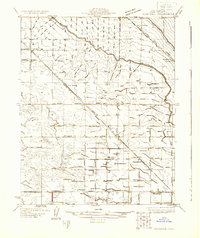 1930 Rosedale1930 Print · USGSRosedale and the surrounding Kern County landscape appear here in the early thirties as a thriving agricultural and rail-oriented community. Researchers can locate the White Church, Palm Sch, and transit points like Rosedale Sta or Una Siding.
 - 1931 Map of Rio Bravo
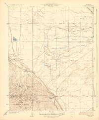
 1931 Rio Bravo1931 Print · USGSKern County was undergoing a period of significant growth in the early 1930s as irrigation and oil transformed the landscape. Researchers can trace the development of rural education and commerce at Rio Bravo Sch and the Rio Bravo Store, or follow the path of the Southern Pacific railroad.3 unique versions available
 - 1932 Map of Stevens
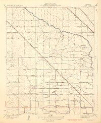
 1932 Stevens1932 Print · USGSCentral California's agricultural and oil-producing heartland comes into focus in the early 1930s near the Kern River. Family historians can trace the locations of the Munzer Sch and Buena Vista Sch alongside the tracks of the Southern Pacific.3 unique versions available
 - 1933 Map of Tupman
 1933 Tupman1933 Print · USGSThe oil fields of Kern County come alive in this early 1930s survey, showing the peak of industrial settlement in the Elk Hills. Genealogists can locate specific worker housing at the Standard Oil Co Camp or trace the early course of the Buena Vista Slough.3 unique versions available
 - 1933 Map of Rosedale
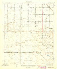
 1933 Rosedale1933 Print · USGSKern County's irrigation and rail networks are in full view in this early 1930s survey of the Rosedale area. Genealogists can locate family-named landmarks and essential rural institutions like Palm Sch, the White Ch, and the stop at Una Siding.3 unique versions available
End of results
Showing maps 1-5 of 5
Top cities near Rosedale
Top neighborhoods of Rosedale
Frequently asked questions
- What are the different types of historical maps available for Rosedale?
- What is the oldest map of Rosedale?
- Where can I purchase historical maps of Rosedale for my home or office?
- Where can I download high-res historical maps of Rosedale?
- Are there historical topographic maps available for Rosedale?
- Is there historical aerial imagery available for Rosedale?
- Where are historical maps of Rosedale sourced from?