Old Maps of Rosedale, California for Academic Research
Study the evolution of Rosedale with 40 high-resolution historic maps. Whether you're teaching, researching, or modeling changes in land use, these maps provide essential visual documentation of urban, environmental, and geographic change.
- Analyze long-term change: Track patterns in development, transportation, and natural features.
- Ideal for environmental or urban studies: Support academic projects with primary historical map data.
- Use in the classroom or lab: Educators and researchers rely on these maps to bring historical context to life.
These maps are a powerful tool for teaching, research, and visualizing how Rosedale has changed over the decades.
Rosedale, CA maps
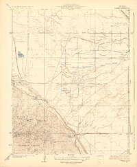
(40)- 1910 Map of Buena Vista Lake, 1912 Print
 1910 Buena Vista Lake1912 Print · USGSThe southern San Joaquin Valley comes to life in the years before the great lakes were drained for agriculture. Genealogists and historians can trace early rail stops like Bowerbank and Hazelton or locate rural landmarks such as the Palm School and Moron Taft P O.
 - 1912 Map of Buena Vista Lake, 1921 Print
 1912 Buena Vista Lake1921 Print · USGSThe San Joaquin Valley at the height of its irrigation and oil boom is captured here, from the streets of Bakersfield to the shores of Buena Vista Lake. Genealogists and local historians can trace early schools like Old River School and the rail stops of the Sunset RR.4 unique versions available
 - 1929 Map of Stevens
 1929 Stevens1929 Print · USGSThe Kern River valley in the late 1920s was a hub of early irrigation and oil development. Researchers can trace the legacy of local education and industry through sites like Munzer Sch, the Elmer Oil Company, and the Rio Bravo Oil Pumping Station.
 - 1929 Map of Coles Levee
 1929 Coles Levee1929 Print · USGSKern County in the late twenties shows a landscape defined by water engineering and early transport. You can trace the Southern Pacific RR and find sites like the Mesquite Hunting Club and the Western Water Co Pumping Plant.
 - 1930 Map of Rosedale
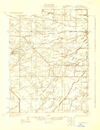
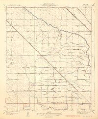
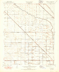
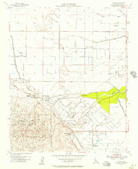
 1930 Rosedale1930 Print · USGSRosedale and the surrounding Kern County landscape appear here in the early thirties as a thriving agricultural and rail-oriented community. Researchers can locate the White Church, Palm Sch, and transit points like Rosedale Sta or Una Siding.
 - 1931 Map of Rio Bravo
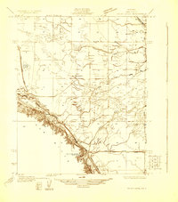
 1931 Rio Bravo1931 Print · USGSKern County was undergoing a period of significant growth in the early 1930s as irrigation and oil transformed the landscape. Researchers can trace the development of rural education and commerce at Rio Bravo Sch and the Rio Bravo Store, or follow the path of the Southern Pacific railroad.3 unique versions available
 - 1932 Map of Stevens
 1932 Stevens1932 Print · USGSCentral California's agricultural and oil-producing heartland comes into focus in the early 1930s near the Kern River. Family historians can trace the locations of the Munzer Sch and Buena Vista Sch alongside the tracks of the Southern Pacific.3 unique versions available
 - 1933 Map of Tupman
 1933 Tupman1933 Print · USGSThe oil fields of Kern County come alive in this early 1930s survey, showing the peak of industrial settlement in the Elk Hills. Genealogists can locate specific worker housing at the Standard Oil Co Camp or trace the early course of the Buena Vista Slough.3 unique versions available
 - 1933 Map of Rosedale
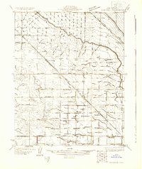
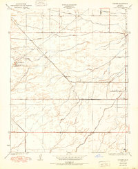
 1933 Rosedale1933 Print · USGSKern County's irrigation and rail networks are in full view in this early 1930s survey of the Rosedale area. Genealogists can locate family-named landmarks and essential rural institutions like Palm Sch, the White Ch, and the stop at Una Siding.3 unique versions available
 - 1942 Map of Buttonwillow
 1942 Buttonwillow1942 Print · USGSKern County's agricultural and energy heartland is meticulously detailed in this wartime survey of the San Joaquin Valley. Researchers can trace family ranch boundaries like Woolner Ranch, locate the Rio Bravo Oil Field, and follow the Southern Pacific McKittrick Branch rail line.
 - 1942 Map of Bakersfield West, 1944 Print
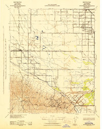
 1942 Bakersfield West1944 Print · USGSBakersfield and the surrounding oil fields are shown here during the early war years, revealing a landscape defined by petroleum and irrigation. Genealogists can locate family holdings near Rosedale, Pumpkin Center, or early schoolhouses like Greeley Sch.
 - 1948 Map of Bakersfield
 1948 Bakersfield1948 Print · USGSBakersfield and the southern San Joaquin Valley appear in the late 1940s, showing a landscape of burgeoning oil towns, rail junctions, and early irrigation canals. Genealogists and historians can trace the foundations of local industry through Gardner Field, the Sunset Railway, and the shores of Buena Vista Lake.2 unique versions available
 - 1950 Map of Rosedale
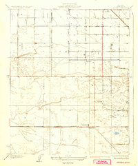
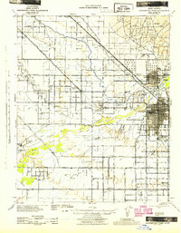
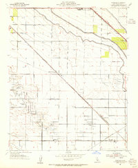
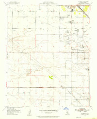
 1950 Rosedale1950 Print · USGSThe Rosedale area of Kern County is shown during a period of significant agricultural expansion and rail development. Researchers can trace early irrigation networks like the Calloway Canal and locate vanished local landmarks such as Una Siding and Palm Sch.
 - 1950 Map of Stevens
 1950 Stevens1950 Print · USGSMid-century Kern County is defined here by its complex irrigation networks and oil infrastructure just as the valley's agricultural character was fully maturing. Researchers can trace the Southern Pacific rail line through Stevens or locate landmarks like the Rio Bravo Oil Pumping Sta and Munzer Sch.
 - 1954 Map of Rosedale, 1955 Print
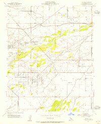
 1954 Rosedale1955 Print · USGSKern County's oil and agricultural heartland is captured here in the mid-1950s during a period of industrial intensification. Researchers can trace the development of the Rosedale Oil Field alongside local landmarks like Shafter Cemetery and Greeley Sch.3 unique versions available
 - 1954 Map of Stevens, 1955 Print
 1954 Stevens1955 Print · USGSMid-century Kern County is defined here by its massive petroleum infrastructure and the industrial corridors of the San Joaquin Valley. Researchers can trace the legacy of the Ten Section Oil Field, find the Buena Vista Sch, and locate the Ten Section Refinery near Stevens.4 unique versions available
 - 1954 Map of Tupman, 1957 Print
 1954 Tupman1957 Print · USGSKern County’s industrial and natural borders met in the 1950s where petroleum reserves and wildlife refuges lined the valley floor. Researchers can trace the layout of the North Coles Levee Oil Field and find community landmarks like the Elk Hills School and Tupman.3 unique versions available
 - 1954 Map of Rio Bravo, 1957 Print
 1954 Rio Bravo1957 Print · USGSCentral California's oil and agricultural landscape comes into focus in the mid-fifties, centered on the southern San Joaquin Valley. Trace early community sites like Mexican Colony and the Rio Bravo Oil Field alongside the Southern Pacific rail line.5 unique versions available
 - 1955 Map of Bakersfield
 1955 Bakersfield1955 Print · USGSThe southern San Joaquin Valley in the mid-fifties shows an era of massive oil production and industrial irrigation. Trace family roots in Allensworth, the oil fields of Oildale, or the shorelines of Tulare Lake and Buena Vista Lake.
 - 1956 Map of Bakersfield
 1956 Bakersfield1956 Print · USGSThe southern San Joaquin Valley and High Sierra come alive in the mid-fifties, showing the region's complex agricultural and rail networks. Genealogists and historians can trace family roots in towns like Bakersfield, Taft, and Delano, or locate early infrastructure along the Sunset Railway.
 - 1960 Map of Bakersfield
 1960 Bakersfield1960 Print · USGSThe Southern San Joaquin Valley at mid-century reveals a complex landscape of petroleum development and massive irrigation projects. Researchers can trace the rail lines of the Southern Pacific, explore oil-era landmarks like Oil City, and locate early settlements including Allensworth and Pixley.2 unique versions available
 - 1962 Map of Bakersfield, 1969 Print
 1962 Bakersfield1969 Print · USGSThe Southern San Joaquin Valley is shown in the 1960s as a bustling intersection of petroleum production, irrigation agriculture, and mountain recreation. Researchers can trace the rail lines of the Southern Pacific through the valley or locate early desert developments like California City and Tehachapi.4 unique versions available
 - 1966 Map of Bakersfield
 1966 Bakersfield1966 Print · USGSThe southern San Joaquin Valley in the mid-sixties reveals a massive industrial and agricultural landscape shaped by water and oil. Genealogists and historians can trace the growth of Bakersfield and Oildale, or locate remote airfields like Minter Field and Mojave-Kern County No. 7 Airport.
 - 1981 Map of Taft, 1982 Print
 1981 Taft1982 Print · USGSKern County's oil country and the high desert of the San Luis Obispo border come into focus during the early eighties. Researchers can trace the industrial landscape of Naval Petroleum Reserve No 1 alongside settlements like Taft, McKittrick, and the San Andreas Rift Zone.2 unique versions available
 - 2012 Map of Rio Bravo, 2012 Print
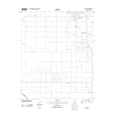 2012 Rio Bravo2012 Print · USGSCovers Rosedale, including Shafter, Thomas Lane, and other nearby areas
Showing maps 1-25 of 40
Top cities near Rosedale
Top neighborhoods of Rosedale
Frequently asked questions
- What are the different types of historical maps available for Rosedale?
- What is the oldest map of Rosedale?
- Where can I purchase historical maps of Rosedale for my home or office?
- Where can I download high-res historical maps of Rosedale?
- Are there historical topographic maps available for Rosedale?
- Is there historical aerial imagery available for Rosedale?
- Where are historical maps of Rosedale sourced from?