1940s Maps of Shafter, California
Explore 5 historic maps of Shafter from the 1940s. These maps offer a rare glimpse into what life looked like during the 1940s — showing old roads, neighborhoods, homes, and landmarks that have changed or disappeared over time.
Whether you're researching your family's past, planning a metal detecting trip, or studying how Shafter's landscape evolved across the 1940s, these high-resolution maps are a powerful tool for exploring the history of this region.
- Focus on a specific era: All maps on this page are from the 1940s, giving you a focused view of this time period.
- See what’s changed: Compare century-old streets, trails, and buildings to today's modern landscape using overlays and satellite layers.
- Research with precision: Use these maps for genealogy, historical research, land use analysis, or educational projects.
- View, download, or print: Maps are fully viewable online in high resolution, and can be downloaded or printed for your own records.
Start exploring Shafter's history through authentic maps from the 1940s. This is your window into the past.
Shafter, CA maps
(5)- 1942 Map of Slater
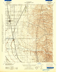 1942 Slater1942 Print · USGSKern County during the early war years shows an landscape of evolving rail towns and major irrigation works. Genealogists and historians can trace the early footprints of McFarland and Famoso, alongside family holdings like the Doyle Ranch and Kimberlina Ranch.
 - 1942 Map of Buttonwillow
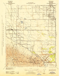 1942 Buttonwillow1942 Print · USGSKern County's agricultural and energy heartland is meticulously detailed in this wartime survey of the San Joaquin Valley. Researchers can trace family ranch boundaries like Woolner Ranch, locate the Rio Bravo Oil Field, and follow the Southern Pacific McKittrick Branch rail line.
 - 1942 Map of Bakersfield West, 1944 Print
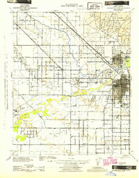 1942 Bakersfield West1944 Print · USGSBakersfield and the surrounding oil fields are shown here during the early war years, revealing a landscape defined by petroleum and irrigation. Genealogists can locate family holdings near Rosedale, Pumpkin Center, or early schoolhouses like Greeley Sch.
 - 1943 Map of Wasco
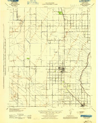 1943 Wasco1943 Print · USGSAgricultural and oil interests converge in 1940s Kern County as the irrigation network expands. Genealogists can trace family holdings like Goose Lake Ranch or local landmarks including Pondham Sch and the Wasco Oil Field.
 - 1948 Map of Bakersfield
 1948 Bakersfield1948 Print · USGSBakersfield and the southern San Joaquin Valley appear in the late 1940s, showing a landscape of burgeoning oil towns, rail junctions, and early irrigation canals. Genealogists and historians can trace the foundations of local industry through Gardner Field, the Sunset Railway, and the shores of Buena Vista Lake.2 unique versions available
End of results
Showing maps 1-5 of 5
Top cities near Shafter
- Bakersfield historical maps
- Wasco historical maps
- McFarland historical maps
- Buttonwillow historical maps
Top neighborhoods of Shafter
- Minter Village historical maps
- Hights Corner historical maps
- North Shafter historical maps
- Myricks Corner historical maps
Frequently asked questions
- What are the different types of historical maps available for Shafter?
- What is the oldest map of Shafter?
- Where can I purchase historical maps of Shafter for my home or office?
- Where can I download high-res historical maps of Shafter?
- Are there historical topographic maps available for Shafter?
- Is there historical aerial imagery available for Shafter?
- Where are historical maps of Shafter sourced from?