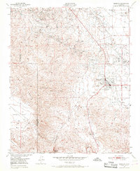
1950s Maps of Taft, California
Explore 6 historic maps of Taft from the 1950s. These maps offer a rare glimpse into what life looked like during the 1950s — showing old roads, neighborhoods, homes, and landmarks that have changed or disappeared over time.
Whether you're researching your family's past, planning a metal detecting trip, or studying how Taft's landscape evolved across the 1950s, these high-resolution maps are a powerful tool for exploring the history of this region.
- Focus on a specific era: All maps on this page are from the 1950s, giving you a focused view of this time period.
- See what’s changed: Compare century-old streets, trails, and buildings to today's modern landscape using overlays and satellite layers.
- Research with precision: Use these maps for genealogy, historical research, land use analysis, or educational projects.
- View, download, or print: Maps are fully viewable online in high resolution, and can be downloaded or printed for your own records.
Start exploring Taft's history through authentic maps from the 1950s. This is your window into the past.
Taft, CA maps
(6)- 1950 Map of Taft, 1960 Print
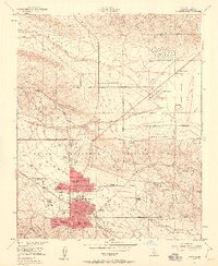 1950 Taft1960 Print · USGSThe Kern County oil patch is at its mid-century peak here, defined by the federal petroleum reserves and company housing. Researchers can trace the layout of specific company camps like Standard Oil Camp 11-C and the Southern Calif Gas Camp.5 unique versions available
 - 1950 Map of Maricopa, 1965 Print
 1950 Maricopa1965 Print · USGSMaricopa and the southern San Joaquin Valley are captured here during the 1950s oil boom. Researchers can trace the industrial footprint of Oil Wells and the Norwalk Oil Refinery alongside small settlements like Spellacy and Hazelton.2 unique versions available
 - 1951 Map of Taft
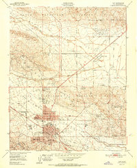 1951 Taft1951 Print · USGSCentral California's oil fields are shown in peak production during the early fifties, centering on the city of Taft. Researchers can trace company-founded settlements like Honolulu Oil Main Camp, the Standard Oil Tank Farm, and Dustin Acres.
 - 1951 Map of Maricopa
 1951 Maricopa1951 Print · USGSThe oil-rich landscape of southern Kern County is captured here in the early 1950s, showing the height of local petroleum production. Researchers can trace the industrial footprint of the Norwalk Oil Refinery and find old settlements like Spellacy and Hazelton.
 - 1955 Map of Bakersfield
 1955 Bakersfield1955 Print · USGSThe southern San Joaquin Valley in the mid-fifties shows an era of massive oil production and industrial irrigation. Trace family roots in Allensworth, the oil fields of Oildale, or the shorelines of Tulare Lake and Buena Vista Lake.
 - 1956 Map of Bakersfield
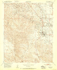
 1956 Bakersfield1956 Print · USGSThe southern San Joaquin Valley and High Sierra come alive in the mid-fifties, showing the region's complex agricultural and rail networks. Genealogists and historians can trace family roots in towns like Bakersfield, Taft, and Delano, or locate early infrastructure along the Sunset Railway.
End of results
Showing maps 1-6 of 6
Top cities near Taft
Top neighborhoods of Taft
Frequently asked questions
- What are the different types of historical maps available for Taft?
- What is the oldest map of Taft?
- Where can I purchase historical maps of Taft for my home or office?
- Where can I download high-res historical maps of Taft?
- Are there historical topographic maps available for Taft?
- Is there historical aerial imagery available for Taft?
- Where are historical maps of Taft sourced from?