1960s Maps of Twin Lakes, California
Explore 2 historic maps of Twin Lakes from the 1960s. These maps offer a rare glimpse into what life looked like during the 1960s — showing old roads, neighborhoods, homes, and landmarks that have changed or disappeared over time.
Whether you're researching your family's past, planning a metal detecting trip, or studying how Twin Lakes's landscape evolved across the 1960s, these high-resolution maps are a powerful tool for exploring the history of this region.
- Focus on a specific era: All maps on this page are from the 1960s, giving you a focused view of this time period.
- See what’s changed: Compare century-old streets, trails, and buildings to today's modern landscape using overlays and satellite layers.
- Research with precision: Use these maps for genealogy, historical research, land use analysis, or educational projects.
- View, download, or print: Maps are fully viewable online in high resolution, and can be downloaded or printed for your own records.
Start exploring Twin Lakes's history through authentic maps from the 1960s. This is your window into the past.
Twin Lakes, CA maps
(2)- 1965 Map of Liebre Twins, 1967 Print
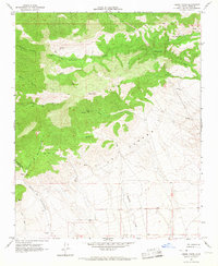 1965 Liebre Twins1967 Print · USGSKern County’s high desert and mountain interface is captured here in the mid-1960s, showing a landscape defined by seasonal water and remote trails. Researchers can trace early infrastructure like the Quarry or follow the JEEP TRAILS that connect Twin Lakes to the Liebre Twins.2 unique versions available
 - 1966 Map of Los Angeles
 1966 Los Angeles1966 Print · USGSSouthern California underwent a mid-century transformation as suburban grids reached the base of the San Gabriel Mountains. Researchers can trace the path of the Los Angeles Aqueduct or locate defense landmarks like Edwards Air Force Base.
End of results
Showing maps 1-2 of 2
Top cities near Twin Lakes
- Lancaster historical maps
- Rosamond historical maps
- Tehachapi historical maps
- Golden Hills historical maps
Frequently asked questions
- What are the different types of historical maps available for Twin Lakes?
- What is the oldest map of Twin Lakes?
- Where can I purchase historical maps of Twin Lakes for my home or office?
- Where can I download high-res historical maps of Twin Lakes?
- Are there historical topographic maps available for Twin Lakes?
- Is there historical aerial imagery available for Twin Lakes?
- Where are historical maps of Twin Lakes sourced from?