Old Maps of Castle Rock Springs, California for Genealogy
Trace your family roots with 12 historic maps of Castle Rock Springs. These high-res maps reveal old neighborhoods, homesites, landmarks, and streets — helping you uncover where your ancestors lived and how the area evolved over time.
- Explore historic neighborhoods: Identify where your relatives may have lived in the 1800s or 1900s.
- Compare maps over time: Trace the changes in streets, buildings, and landmarks for multi-generational research.
- Perfect for genealogy & ancestry research: Used by family historians and researchers to map out lineage and migration.
These maps are an incredible resource for exploring your personal connection to Castle Rock Springs's past.
Castle Rock Springs, CA maps
(12)- 1945 Map of Lower Lake
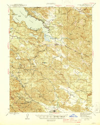 1945 Lower Lake1945 Print · USGSCovers Castle Rock Springs, including Clearlake, Clearlake Riviera, and other nearby areas2 unique versions available
 - 1947 Map of Santa Rosa
 1947 Santa Rosa1947 Print · USGSCovers Castle Rock Springs, including Santa Rosa, Concord, and other nearby areas
 - 1949 Map of Santa Rosa
 1949 Santa Rosa1949 Print · USGSCovers Castle Rock Springs, including Santa Rosa, Concord, and other nearby areas2 unique versions available
 - 1958 Map of Whispering Pines, 1961 Print
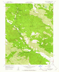 1958 Whispering Pines1961 Print · USGSCovers Castle Rock Springs, including Cobb, Loch Lomond, and other nearby areas4 unique versions available
 - 1958 Map of Lower Lake, 1962 Print
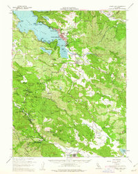 1958 Lower Lake1962 Print · USGSCovers Castle Rock Springs, including Clearlake, Clearlake Riviera, and other nearby areas2 unique versions available
 - 1958 Map of Santa Rosa, 1968 Print
 1958 Santa Rosa1968 Print · USGSCovers Castle Rock Springs, including Santa Rosa, Concord, and other nearby areas3 unique versions available
 - 1962 Map of Santa Rosa
 1962 Santa Rosa1962 Print · USGSCovers Castle Rock Springs, including Santa Rosa, Concord, and other nearby areas
 - 1964 Map of Santa Rosa
 1964 Santa Rosa1964 Print · USGSCovers Castle Rock Springs, including Santa Rosa, Concord, and other nearby areas
 - 1972 Map of Healdsburg, 1975 Print
 1972 Healdsburg1975 Print · USGSCovers Castle Rock Springs, including Santa Rosa, Windsor, and other nearby areas2 unique versions available
 - 1993 Map of Whispering Pines
 1993 Whispering Pines1993 Print · USGSCovers Castle Rock Springs, including Cobb, Loch Lomond, and other nearby areas
 - 1998 Map of Whispering Pines, 2002 Print
 1998 Whispering Pines2002 Print · USGSCovers Castle Rock Springs, including Cobb, Loch Lomond, and other nearby areas
 - 2021 Map of Whispering Pines, 2021 Print
 2021 Whispering Pines2021 Print · USGSCovers Castle Rock Springs, including Cobb, Whispering Pines, and other nearby areas
End of results
Showing maps 1-12 of 12
Top cities near Castle Rock Springs
- Windsor historical maps
- Clearlake historical maps
- Healdsburg historical maps
- Calistoga historical maps
- Clearlake Riviera historical maps
- Kelseyville historical maps
See more
Frequently asked questions
- What are the different types of historical maps available for Castle Rock Springs?
- What is the oldest map of Castle Rock Springs?
- Where can I purchase historical maps of Castle Rock Springs for my home or office?
- Where can I download high-res historical maps of Castle Rock Springs?
- Are there historical topographic maps available for Castle Rock Springs?
- Is there historical aerial imagery available for Castle Rock Springs?
- Where are historical maps of Castle Rock Springs sourced from?