1970s Maps of Lower Lake, California
Explore 2 historic maps of Lower Lake from the 1970s. These maps offer a rare glimpse into what life looked like during the 1970s — showing old roads, neighborhoods, homes, and landmarks that have changed or disappeared over time.
Whether you're researching your family's past, planning a metal detecting trip, or studying how Lower Lake's landscape evolved across the 1970s, these high-resolution maps are a powerful tool for exploring the history of this region.
- Focus on a specific era: All maps on this page are from the 1970s, giving you a focused view of this time period.
- See what’s changed: Compare century-old streets, trails, and buildings to today's modern landscape using overlays and satellite layers.
- Research with precision: Use these maps for genealogy, historical research, land use analysis, or educational projects.
- View, download, or print: Maps are fully viewable online in high resolution, and can be downloaded or printed for your own records.
Start exploring Lower Lake's history through authentic maps from the 1970s. This is your window into the past.
Lower Lake, CA maps
(2)- 1972 Map of Healdsburg, 1975 Print
 1972 Healdsburg1975 Print · USGSNorthern California wine country and the lower Lake County basins appear here during the early seventies. Trace the Northwestern Pacific rail line and discover foothill communities like Middletown and Loch Lomond.2 unique versions available
 - 1977 Map of Lower Lake, 1980 Print
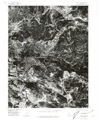 1977 Lower Lake1980 Print · USGSThe township of Lower Lake and the pastoral Excelsior Valley appear in sharp detail in this late-1970s aerial survey. Researchers can trace the mid-century development of the town and follow the path of Cache Creek through the landscape.
End of results
Showing maps 1-2 of 2
Top cities near Lower Lake
- Clearlake historical maps
- Clearlake Riviera historical maps
- Lucerne historical maps
- Clearlake Oaks historical maps
- Cobb historical maps
- Spring Valley historical maps
See more
Frequently asked questions
- What are the different types of historical maps available for Lower Lake?
- What is the oldest map of Lower Lake?
- Where can I purchase historical maps of Lower Lake for my home or office?
- Where can I download high-res historical maps of Lower Lake?
- Are there historical topographic maps available for Lower Lake?
- Is there historical aerial imagery available for Lower Lake?
- Where are historical maps of Lower Lake sourced from?