1930s Maps of Antelope Acres, California
Explore 2 historic maps of Antelope Acres from the 1930s. These maps offer a rare glimpse into what life looked like during the 1930s — showing old roads, neighborhoods, homes, and landmarks that have changed or disappeared over time.
Whether you're researching your family's past, planning a metal detecting trip, or studying how Antelope Acres's landscape evolved across the 1930s, these high-resolution maps are a powerful tool for exploring the history of this region.
- Focus on a specific era: All maps on this page are from the 1930s, giving you a focused view of this time period.
- See what’s changed: Compare century-old streets, trails, and buildings to today's modern landscape using overlays and satellite layers.
- Research with precision: Use these maps for genealogy, historical research, land use analysis, or educational projects.
- View, download, or print: Maps are fully viewable online in high resolution, and can be downloaded or printed for your own records.
Start exploring Antelope Acres's history through authentic maps from the 1930s. This is your window into the past.
Antelope Acres, CA maps
(2)- 1931 Map of Esperanza School
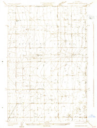 1931 Esperanza School1931 Print · USGSAntelope Valley in the early 1930s is a landscape of surveyed grids and scattered desert wells. Researchers can trace the early community at the Esperanza Sch, find the Japanese Ch, and locate the small settlement of Rogers near the county line.
 - 1934 Map of Esperanza School
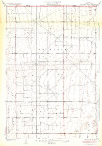 1934 Esperanza School1934 Print · USGSAntelope Valley's high desert landscape comes into focus during the early 1930s as a developing agricultural and social hub. Genealogists can trace early local landmarks like the Japanese Ch, Rogers Sch, and Esperanza Sch.3 unique versions available
End of results
Showing maps 1-2 of 2
Top cities near Antelope Acres
Frequently asked questions
- What are the different types of historical maps available for Antelope Acres?
- What is the oldest map of Antelope Acres?
- Where can I purchase historical maps of Antelope Acres for my home or office?
- Where can I download high-res historical maps of Antelope Acres?
- Are there historical topographic maps available for Antelope Acres?
- Is there historical aerial imagery available for Antelope Acres?
- Where are historical maps of Antelope Acres sourced from?