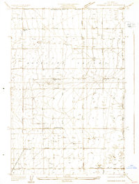
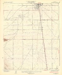
1931 Map of Esperanza School
USGS Topo · Published 1931About this map
Antelope Valley is defined by a rigid grid of surveyed roads and the essential pursuit of water in this 1931 survey. The landscape is dotted with dozens of individual wells, a testament to the agricultural development of the high desert prior to mid-century urbanization. Along Avenue G, the Esperanza Sch serves as a local landmark for the surrounding rural community, while the Japanese Ch near Avenue E reflects the specific cultural and social groups settling this portion of Los Angeles County. Infrastructure for the growing region is evident in the Southern California Edison Co Trans Line and a dedicated Sub Station, marking the expansion of electrical power across the valley. The small settlement of Rogers appears in the northwest, situated near the Los Angeles Co-Kern Co Boundary Line, where the transition from desert floor to rising terrain begins.
Find a feature on this map
22 named features on this map. Tap any name to fly to it.
Don’t see what you’re looking for? This feature index may not catch every label — zoom into the map to look around manually.
Map Details
Editions of this 1931 Esperanza School Map
This is the sole edition of this map. No revisions or reprints were ever made.
Other maps of this area

1915 · Elizabeth Lake
USGS Topo · 1:125,000

1917 · Elizabeth Lake
USGS Topo · 1:125,000

1930 · Oban
USGS Topo · 1:24,000
1930 · Lancaster
USGS Topo · 1:24,000
1931 · Little Buttes
USGS Topo · 1:24,000
1931 · Del Sur
USGS Topo · 1:24,000
1932 · Lake
USGS Topo · 1:24,000
1933 · Lancaster
USGS Topo · 1:24,000
1933 · Oban
USGS Topo · 1:24,000
1934 · Little Buttes
USGS Topo · 1:24,000