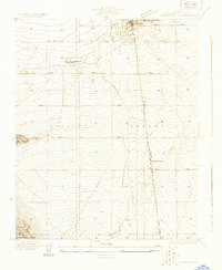
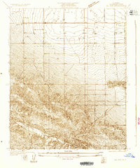
1930 Map of Lancaster
USGS Topo · Published 1930About this map
Lancaster Tubercular Rest Home stands as a significant landmark in this early 1930s survey, reflecting the region's climate-driven healthcare history before the era of modern antibiotics. The town of Lancaster is depicted in its formative stage, organized around the Southern Pacific railroad line which facilitated the growth of this desert community. The map reveals a transition from a centralized grid near the Antelope Valley High Sch to a sprawling network of dirt roads like Del Sur Road and Tierra Bonita Road that carve through the arid floor of the Antelope Valley. South of the main settlement, the topography shifts abruptly toward Quartz Hill and the prominent Ritter Ridge. This document captures the infrastructure of a nascent agricultural and transit hub, punctuated by isolated rail features like Denis Siding.
Find a feature on this map
16 named features on this map. Tap any name to fly to it.
Don’t see what you’re looking for? This feature index may not catch every label — zoom into the map to look around manually.
Map Details
Editions of this 1930 Lancaster Map
This is the sole edition of this map. No revisions or reprints were ever made.
Other maps of this area

1915 · Elizabeth Lake
USGS Topo · 1:125,000

1917 · Elizabeth Lake
USGS Topo · 1:125,000

1930 · Oban
USGS Topo · 1:24,000
1930 · Roosevelt School
USGS Topo · 1:24,000
1930 · Pearland
USGS Topo · 1:24,000
1930 · Tierra Bonita
USGS Topo · 1:24,000
1931 · Del Sur
USGS Topo · 1:24,000
1931 · Esperanza School
USGS Topo · 1:24,000
1932 · Red Rover
USGS Topo · 1:24,000
1932 · Palmdale
USGS Topo · 1:24,000