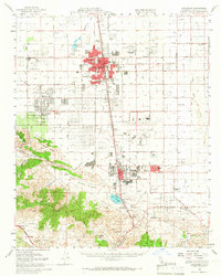
1958 Map of Lancaster
USGS Topo · Published 1966About this map
Lancaster and Palmdale anchor this late-1950s study of the Antelope Valley, showing the region as it transitioned from agricultural roots to a Cold War aerospace hub. The massive footprint of Air Force Plant 42 dominates the center of the sheet, while the Southern Pacific rail line and Sierra Highway corridor dictate the layout of the valley's growing residential grids. To the west, the Mira Loma Detention Facility sits near Quartz Hill, where irrigation and small-scale ranching like Messer Ranch persist despite the encroachment of suburban expansion. The southern portion of the map climbs into the Sierra Pelona range, revealing the high-desert's mining legacy at the Governor Mine and Red Rover Mine. This landscape is one of stark contrasts, where modern school districts like Sierra Sch and Joshua School serve new communities built alongside traditional desert landmarks like Lake Palmdale and the ephemeral Amargosa Creek.
Find a feature on this map
46 named features on this map. Tap any name to fly to it.
Don’t see what you’re looking for? This feature index may not catch every label — zoom into the map to look around manually.
Map Details
Editions of this 1958 Lancaster Map
2 editions found
Other maps of this area

1900 · Tujunga
USGS Topo · 1:62,500

1900 · Fernando
USGS Topo · 1:62,500

1901 · Southern California Sheet No. 1
USGS Topo · 1:250,000

1903 · Rock Creek
USGS Topo · 1:62,500

1904 · Southern California Sheet No. 1
USGS Topo · 1:250,000

1915 · Elizabeth Lake
USGS Topo · 1:125,000

1917 · Elizabeth Lake
USGS Topo · 1:125,000

1930 · Oban
USGS Topo · 1:24,000

1930 · Roosevelt School
USGS Topo · 1:24,000

1930 · Little Rock
USGS Topo · 1:24,000