
Loading...
Loading map...1915 Map of Elizabeth Lake
USGS Topo · Published 1915About this map
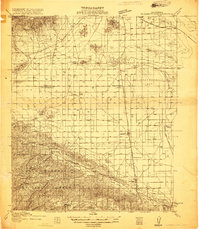
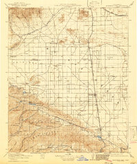
Antelope Valley and the northern slopes of the Sierra Pelona define this 1915 survey, which captures the infrastructure of the newly completed Los Angeles Aqueduct and its Antelope Valley Pumping Sta. The desert landscape is marked by the influence of the Southern Pacific and Atchison Topeka and Santa Fe railroads, which facilitated the development of early settlements like Lancaster, Palmdale, and Rosamond.
Find a feature on this map
71 named features on this map. Tap any name to fly to it.
Don’t see what you’re looking for? This feature index may not catch every label — zoom into the map to look around manually.
Map Details
Date Portrayed1915
Date Published1915
PublisherU.S. Geological Survey
Map TypeTopographic
Scale1:125,000
Physical Dimensions16.5 x 20.8 inches
Editions of this 1915 Elizabeth Lake Map
2 editions found
Historical Maps of Palmdale Through Time
Featured Locations
Source Details
SourceU.S. Geological Survey
CopyrightPublic Domain