1915 Map of Elizabeth Lake
USGS Topo · Published 1915About this map
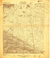
Los Angeles Aqueduct cuts a diagonal path across the arid terrain of Antelope Valley, marking a pivotal moment in California's water history just years after its completion. This 1915 survey captures the region as it transitions from a high-desert frontier into a series of rail-dependent agricultural and transit hubs. The Southern Pacific corridor anchors the developing settlements of Lancaster and Palmdale, while the dry expanse of Rosamond Lake dominates the central basin. The map reveals a landscape defined by its vital infrastructure, from the Antelope Valley Pumping Sta to isolated rural education centers like Esperanza School and Roosevelt School. To the south, the timbered slopes of the Santa Barbara National Forest rise above the Anaverde Valley, providing a stark contrast to the open plains where the Atchison Topeka and Santa Fe railroad skirts the northern foothills of the Tehachapi Mountains.
Find a feature on this map
36 named features on this map. Tap any name to fly to it.
Don’t see what you’re looking for? This feature index may not catch every label — zoom into the map to look around manually.
Map Details
Editions of this 1915 Elizabeth Lake Map
2 editions found
Other maps of this area

1900 · Tujunga
USGS Topo · 1:62,500

1900 · Fernando
USGS Topo · 1:62,500

1901 · Southern California Sheet No. 1
USGS Topo · 1:250,000

1903 · Tejon
USGS Topo · 1:125,000

1903 · Rock Creek
USGS Topo · 1:62,500

1903 · Camulos
USGS Topo · 1:125,000

1903 · Santa Susana
USGS Topo · 1:62,500

1904 · Southern California Sheet No. 1
USGS Topo · 1:250,000

1914 · Caliente
USGS Topo · 1:125,000

1915 · Elizabeth Lake
USGS Topo · 1:125,000