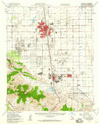
1958 Map of Lancaster
USGS Topo · Published 1960About this map
The San Andreas Fault Zone cuts a distinct southeast-to-northwest diagonal through this High Desert landscape, separating the flat expanse of the Antelope Valley from the rising heights of the Sierra Pelona. In the late 1950s, Lancaster and Palmdale appear as concentrated hubs of development along the Southern Pacific railroad and the Sierra Highway. The industrial character of the era is clearly defined by the massive footprint of Air Force Plant 42 and its Control Tower, contrasting with the surrounding ranching and mining history. To the south, the map details the rugged canyons where the Governor Mine and Red Rover Mine operated near Vincent. Local infrastructure includes numerous schools like Sunnydale Sch and Manzanita School, and institutional sites like the Mira Loma Detention Facility.
Find a feature on this map
52 named features on this map. Tap any name to fly to it.
Don’t see what you’re looking for? This feature index may not catch every label — zoom into the map to look around manually.
Map Details
Editions of this 1958 Lancaster Map
2 editions found
Other maps of this area

1900 · Tujunga
USGS Topo · 1:62,500

1900 · Fernando
USGS Topo · 1:62,500

1901 · Southern California Sheet No. 1
USGS Topo · 1:250,000

1903 · Rock Creek
USGS Topo · 1:62,500

1904 · Southern California Sheet No. 1
USGS Topo · 1:250,000

1915 · Elizabeth Lake
USGS Topo · 1:125,000

1917 · Elizabeth Lake
USGS Topo · 1:125,000

1930 · Oban
USGS Topo · 1:24,000

1930 · Roosevelt School
USGS Topo · 1:24,000

1930 · Little Rock
USGS Topo · 1:24,000